You are here: Home > Network List > TA - USArray Transportable Network (new EarthScope stations) Stations List
> Station 219A White Tail Canyon, San Simon, AZ, USA > Earthquake Result Viewer
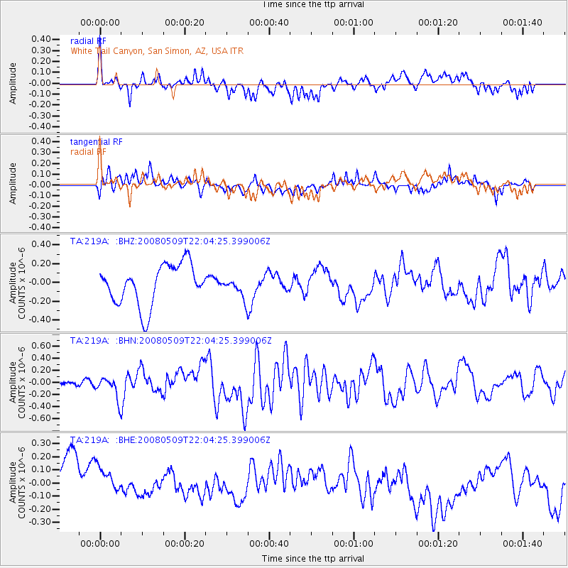
219A White Tail Canyon, San Simon, AZ, USA - Earthquake Result Viewer
*The percent match for this event was below the threshold and hence no stack was calculated.
| Earthquake location: |
South Of Mariana Islands |
| Earthquake latitude/longitude: |
12.5/143.2 |
| Earthquake time(UTC): |
2008/05/09 (130) 21:51:29 GMT |
| Earthquake Depth: |
76 km |
| Earthquake Magnitude: |
6.1 MB, 6.7 MW, 6.7 MW |
| Earthquake Catalog/Contributor: |
WHDF/NEIC |
|
| Network: |
TA USArray Transportable Network (new EarthScope stations) |
| Station: |
219A White Tail Canyon, San Simon, AZ, USA |
| Lat/Lon: |
32.00 N/109.26 W |
| Elevation: |
1581 m |
|
| Distance: |
97.9 deg |
| Az: |
54.86 deg |
| Baz: |
289.97 deg |
| Ray Param: |
$rayparam |
*The percent match for this event was below the threshold and hence was not used in the summary stack. |
|
| Radial Match: |
60.774895 % |
| Radial Bump: |
400 |
| Transverse Match: |
46.890762 % |
| Transverse Bump: |
400 |
| SOD ConfigId: |
2504 |
| Insert Time: |
2010-03-06 17:55:00.207 +0000 |
| GWidth: |
2.5 |
| Max Bumps: |
400 |
| Tol: |
0.001 |
|
Signal To Noise
| Channel | StoN | STA | LTA |
| TA:219A: :BHN:20080509T22:04:25.399006Z | 2.741064 | 1.8463064E-7 | 6.7357284E-8 |
| TA:219A: :BHE:20080509T22:04:25.399006Z | 0.6875147 | 1.2124335E-7 | 1.763502E-7 |
| TA:219A: :BHZ:20080509T22:04:25.399006Z | 0.5370442 | 1.15539876E-7 | 2.1514033E-7 |
| Arrivals |
| Ps | |
| PpPs | |
| PsPs/PpSs | |


