You are here: Home > Network List > UW - Pacific Northwest Regional Seismic Network Stations List
> Station HOOD Mt Hood Meadows, OR CREST BB SMO > Earthquake Result Viewer
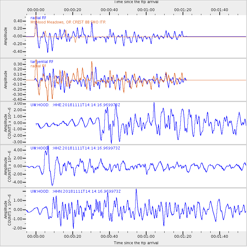
HOOD Mt Hood Meadows, OR CREST BB SMO - Earthquake Result Viewer
*The percent match for this event was below the threshold and hence no stack was calculated.
| Earthquake location: |
North Atlantic Ocean |
| Earthquake latitude/longitude: |
15.6/-49.9 |
| Earthquake time(UTC): |
2018/11/11 (315) 14:03:59 GMT |
| Earthquake Depth: |
10 km |
| Earthquake Magnitude: |
6.2 mb |
| Earthquake Catalog/Contributor: |
NEIC PDE/us |
|
| Network: |
UW Pacific Northwest Regional Seismic Network |
| Station: |
HOOD Mt Hood Meadows, OR CREST BB SMO |
| Lat/Lon: |
45.32 N/121.65 W |
| Elevation: |
1520 m |
|
| Distance: |
66.3 deg |
| Az: |
312.969 deg |
| Baz: |
91.587 deg |
| Ray Param: |
$rayparam |
*The percent match for this event was below the threshold and hence was not used in the summary stack. |
|
| Radial Match: |
76.80741 % |
| Radial Bump: |
400 |
| Transverse Match: |
76.23718 % |
| Transverse Bump: |
400 |
| SOD ConfigId: |
13570011 |
| Insert Time: |
2019-05-01 19:28:39.907 +0000 |
| GWidth: |
2.5 |
| Max Bumps: |
400 |
| Tol: |
0.001 |
|
Signal To Noise
| Channel | StoN | STA | LTA |
| UW:HOOD: :HHZ:20181111T14:14:16.969973Z | 10.605576 | 1.0869779E-6 | 1.0249118E-7 |
| UW:HOOD: :HHN:20181111T14:14:16.969973Z | 1.4442291 | 2.5595864E-7 | 1.7722856E-7 |
| UW:HOOD: :HHE:20181111T14:14:16.969973Z | 1.9088026 | 6.6238664E-7 | 3.4701685E-7 |
| Arrivals |
| Ps | |
| PpPs | |
| PsPs/PpSs | |


