You are here: Home > Network List > UW - Pacific Northwest Regional Seismic Network Stations List
> Station MOX Moxee City, WA, USA (was ISC code MXC) > Earthquake Result Viewer
MOX Moxee City, WA, USA (was ISC code MXC) - Earthquake Result Viewer
| Earthquake location: |
North Atlantic Ocean |
| Earthquake latitude/longitude: |
15.6/-49.9 |
| Earthquake time(UTC): |
2018/11/11 (315) 14:03:59 GMT |
| Earthquake Depth: |
10 km |
| Earthquake Magnitude: |
6.2 mb |
| Earthquake Catalog/Contributor: |
NEIC PDE/us |
|
| Network: |
UW Pacific Northwest Regional Seismic Network |
| Station: |
MOX Moxee City, WA, USA (was ISC code MXC) |
| Lat/Lon: |
46.58 N/120.30 W |
| Elevation: |
501 m |
|
| Distance: |
65.4 deg |
| Az: |
314.386 deg |
| Baz: |
93.137 deg |
| Ray Param: |
0.05827068 |
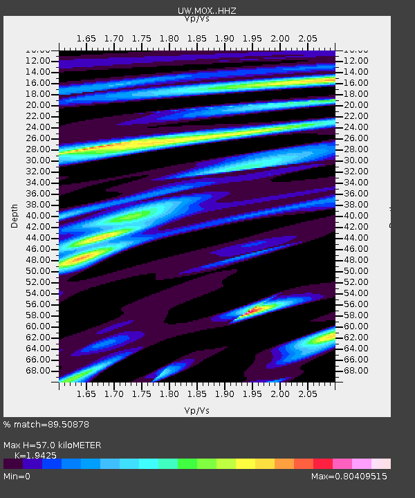
| Estimated Moho Depth: |
57.0 km |
| Estimated Crust Vp/Vs: |
1.94 |
| Assumed Crust Vp: |
6.597 km/s |
| Estimated Crust Vs: |
3.396 km/s |
| Estimated Crust Poisson's Ratio: |
0.32 |
|
| Radial Match: |
89.50878 % |
| Radial Bump: |
400 |
| Transverse Match: |
77.74468 % |
| Transverse Bump: |
400 |
| SOD ConfigId: |
13570011 |
| Insert Time: |
2019-05-01 19:28:48.980 +0000 |
| GWidth: |
2.5 |
| Max Bumps: |
400 |
| Tol: |
0.001 |
|

Signal To Noise
| Channel | StoN | STA | LTA |
| UW:MOX: :HHZ:20181111T14:14:11.250002Z | 8.910462 | 1.5954382E-6 | 1.7905224E-7 |
| UW:MOX: :HHN:20181111T14:14:11.250002Z | 0.6136406 | 7.844015E-8 | 1.2782752E-7 |
| UW:MOX: :HHE:20181111T14:14:11.250002Z | 5.8176756 | 7.0403144E-7 | 1.2101593E-7 |
| Arrivals |
| Ps | 8.5 SECOND |
| PpPs | 24 SECOND |
| PsPs/PpSs | 33 SECOND |


