You are here: Home > Network List > Y916 - Rapid Response for Fairview Aftershock in Oklahoma Stations List
> Station FW07 Waynoka, Oklahoma, USA > Earthquake Result Viewer
FW07 Waynoka, Oklahoma, USA - Earthquake Result Viewer
| Earthquake location: |
North Atlantic Ocean |
| Earthquake latitude/longitude: |
15.6/-49.9 |
| Earthquake time(UTC): |
2018/11/11 (315) 14:03:59 GMT |
| Earthquake Depth: |
10 km |
| Earthquake Magnitude: |
6.2 mb |
| Earthquake Catalog/Contributor: |
NEIC PDE/us |
|
| Network: |
Y9 Rapid Response for Fairview Aftershock in Oklahoma |
| Station: |
FW07 Waynoka, Oklahoma, USA |
| Lat/Lon: |
36.45 N/98.80 W |
| Elevation: |
404 m |
|
| Distance: |
48.1 deg |
| Az: |
305.205 deg |
| Baz: |
102.383 deg |
| Ray Param: |
0.06958991 |
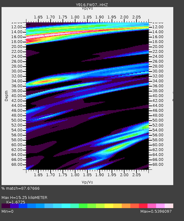
| Estimated Moho Depth: |
15.25 km |
| Estimated Crust Vp/Vs: |
1.67 |
| Assumed Crust Vp: |
6.426 km/s |
| Estimated Crust Vs: |
3.842 km/s |
| Estimated Crust Poisson's Ratio: |
0.22 |
|
| Radial Match: |
87.67666 % |
| Radial Bump: |
279 |
| Transverse Match: |
73.5307 % |
| Transverse Bump: |
400 |
| SOD ConfigId: |
13570011 |
| Insert Time: |
2019-05-01 19:29:39.867 +0000 |
| GWidth: |
2.5 |
| Max Bumps: |
400 |
| Tol: |
0.001 |
|

Signal To Noise
| Channel | StoN | STA | LTA |
| Y9:FW07: :HHZ:20181111T14:12:08.129Z | 11.093668 | 3.1353484E-6 | 2.8262505E-7 |
| Y9:FW07: :HH1:20181111T14:12:08.129Z | 1.3858138 | 4.7845424E-7 | 3.4525146E-7 |
| Y9:FW07: :HH2:20181111T14:12:08.129Z | 5.239705 | 1.9028421E-6 | 3.6315822E-7 |
| Arrivals |
| Ps | 1.7 SECOND |
| PpPs | 5.9 SECOND |
| PsPs/PpSs | 7.6 SECOND |


