You are here: Home > Network List > YX16 - Raton Basin UNM Broadband Network Stations List
> Station UNM3 SW Corner of NM Stations > Earthquake Result Viewer
UNM3 SW Corner of NM Stations - Earthquake Result Viewer
| Earthquake location: |
North Atlantic Ocean |
| Earthquake latitude/longitude: |
15.6/-49.9 |
| Earthquake time(UTC): |
2018/11/11 (315) 14:03:59 GMT |
| Earthquake Depth: |
10 km |
| Earthquake Magnitude: |
6.2 mb |
| Earthquake Catalog/Contributor: |
NEIC PDE/us |
|
| Network: |
YX Raton Basin UNM Broadband Network |
| Station: |
UNM3 SW Corner of NM Stations |
| Lat/Lon: |
36.84 N/105.04 W |
| Elevation: |
2575 m |
|
| Distance: |
53.1 deg |
| Az: |
304.539 deg |
| Baz: |
98.25 deg |
| Ray Param: |
0.06634059 |
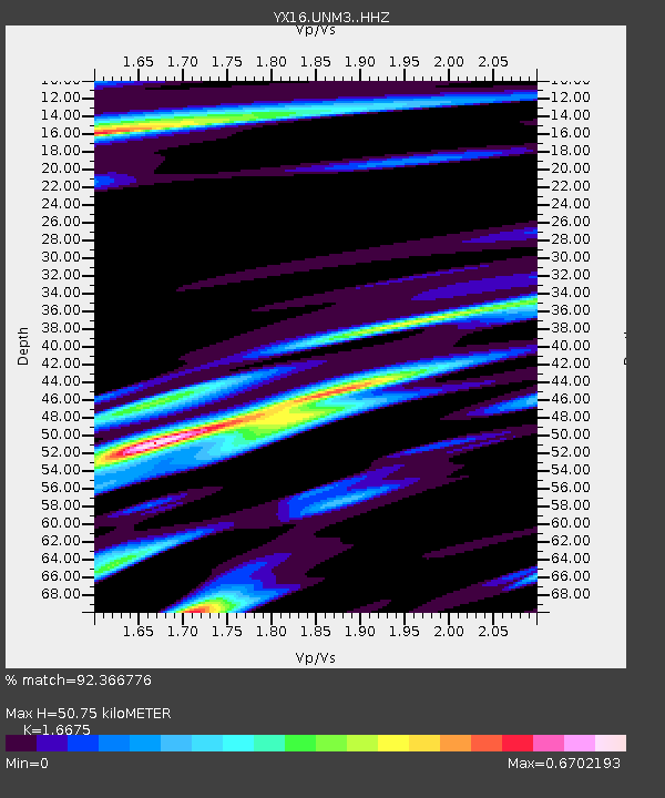
| Estimated Moho Depth: |
50.75 km |
| Estimated Crust Vp/Vs: |
1.67 |
| Assumed Crust Vp: |
6.316 km/s |
| Estimated Crust Vs: |
3.787 km/s |
| Estimated Crust Poisson's Ratio: |
0.22 |
|
| Radial Match: |
92.366776 % |
| Radial Bump: |
338 |
| Transverse Match: |
72.7498 % |
| Transverse Bump: |
400 |
| SOD ConfigId: |
13570011 |
| Insert Time: |
2019-05-01 19:29:48.516 +0000 |
| GWidth: |
2.5 |
| Max Bumps: |
400 |
| Tol: |
0.001 |
|

Signal To Noise
| Channel | StoN | STA | LTA |
| YX:UNM3: :HHZ:20181111T14:12:45.880007Z | 13.578245 | 1.1099131E-6 | 8.174202E-8 |
| YX:UNM3: :HHN:20181111T14:12:45.880007Z | 0.8998014 | 1.6051888E-7 | 1.7839368E-7 |
| YX:UNM3: :HHE:20181111T14:12:45.880007Z | 3.5906749 | 7.355375E-7 | 2.048466E-7 |
| Arrivals |
| Ps | 5.7 SECOND |
| PpPs | 20 SECOND |
| PsPs/PpSs | 26 SECOND |


