You are here: Home > Network List > CN - Canadian National Seismograph Network Stations List
> Station INK INUVIK, NT > Earthquake Result Viewer
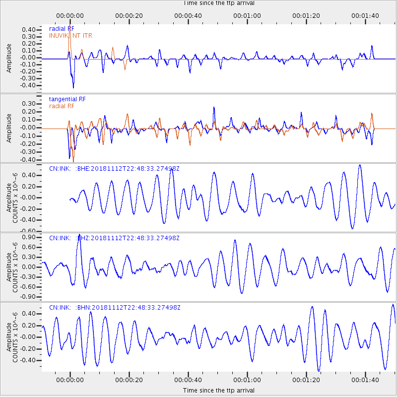
INK INUVIK, NT - Earthquake Result Viewer
*The percent match for this event was below the threshold and hence no stack was calculated.
| Earthquake location: |
Central East Pacific Rise |
| Earthquake latitude/longitude: |
-3.1/-103.4 |
| Earthquake time(UTC): |
2018/11/12 (316) 22:37:27 GMT |
| Earthquake Depth: |
10 km |
| Earthquake Magnitude: |
5.6 Mww |
| Earthquake Catalog/Contributor: |
NEIC PDE/us |
|
| Network: |
CN Canadian National Seismograph Network |
| Station: |
INK INUVIK, NT |
| Lat/Lon: |
68.31 N/133.53 W |
| Elevation: |
44 m |
|
| Distance: |
74.3 deg |
| Az: |
348.83 deg |
| Baz: |
148.649 deg |
| Ray Param: |
$rayparam |
*The percent match for this event was below the threshold and hence was not used in the summary stack. |
|
| Radial Match: |
61.836914 % |
| Radial Bump: |
400 |
| Transverse Match: |
60.667316 % |
| Transverse Bump: |
400 |
| SOD ConfigId: |
13570011 |
| Insert Time: |
2019-05-01 19:33:04.443 +0000 |
| GWidth: |
2.5 |
| Max Bumps: |
400 |
| Tol: |
0.001 |
|
Signal To Noise
| Channel | StoN | STA | LTA |
| CN:INK: :BHZ:20181112T22:48:33.27498Z | 2.627081 | 5.0050426E-7 | 1.9051724E-7 |
| CN:INK: :BHN:20181112T22:48:33.27498Z | 1.5618376 | 2.2590741E-7 | 1.4464207E-7 |
| CN:INK: :BHE:20181112T22:48:33.27498Z | 1.9627502 | 3.5195973E-7 | 1.7931968E-7 |
| Arrivals |
| Ps | |
| PpPs | |
| PsPs/PpSs | |


