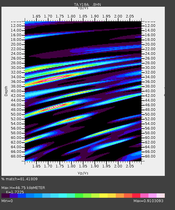
Y19A Nutrioso, AZ, USA - Earthquake Result Viewer

Earthquake location: Andreanof Islands, Aleutian Is.
Earthquake latitude/longitude: 52.2/-175.7
Earthquake time(UTC): 2008/08/07 (220) 18:30:03 GMT
Earthquake Depth: 12 km
Earthquake Magnitude: 5.6 MB, 5.5 MS, 5.8 MW, 5.8 MW
Earthquake Catalog/Contributor: WHDF/NEIC
Network: TA USArray Transportable Network (new EarthScope stations)
Station: Y19A Nutrioso, AZ, USA
Lat/Lon: 33.96 N/109.25 W
Elevation: 2448 m
Distance: 50.0 deg
Az: 84.003 deg
Baz: 312.558 deg
Ray Param: 0.06834959
Estimated Moho Depth: 46.75 km
Estimated Crust Vp/Vs: 1.72
Assumed Crust Vp: 6.276 km/s
Estimated Crust Vs: 3.643 km/s
Estimated Crust Poisson's Ratio: 0.25
Radial Match: 81.41809 %
Radial Bump: 400
Transverse Match: 72.46902 %
Transverse Bump: 400
SOD ConfigId: 2504
Insert Time: 2010-03-06 17:56:11.449 +0000
GWidth: 2.5
Max Bumps: 400
Tol: 0.001

Signal To Noise

ChannelStoNSTALTA
TA:Y19A: :BHN:20080807T18:38:25.998986Z5.9449633.0184097E-75.0772556E-8
TA:Y19A: :BHE:20080807T18:38:25.998986Z2.05790261.4558147E-77.0742644E-8
TA:Y19A: :BHZ:20080807T18:38:25.998986Z2.10683061.0464315E-74.9668518E-8
Arrivals
Ps5.7 SECOND
PpPs19 SECOND
PsPs/PpSs25 SECOND