You are here: Home > Network List > TA - USArray Transportable Network (new EarthScope stations) Stations List
> Station Y19A Nutrioso, AZ, USA > Earthquake Result Viewer
Y19A Nutrioso, AZ, USA - Earthquake Result Viewer
| Earthquake location: |
Jujuy Province, Argentina |
| Earthquake latitude/longitude: |
-22.6/-66.3 |
| Earthquake time(UTC): |
2007/11/18 (322) 05:40:12 GMT |
| Earthquake Depth: |
246 km |
| Earthquake Magnitude: |
5.7 MB, 6.0 MW, 6.0 MW |
| Earthquake Catalog/Contributor: |
WHDF/NEIC |
|
| Network: |
TA USArray Transportable Network (new EarthScope stations) |
| Station: |
Y19A Nutrioso, AZ, USA |
| Lat/Lon: |
33.96 N/109.25 W |
| Elevation: |
2448 m |
|
| Distance: |
69.5 deg |
| Az: |
322.827 deg |
| Baz: |
137.812 deg |
| Ray Param: |
0.054853555 |
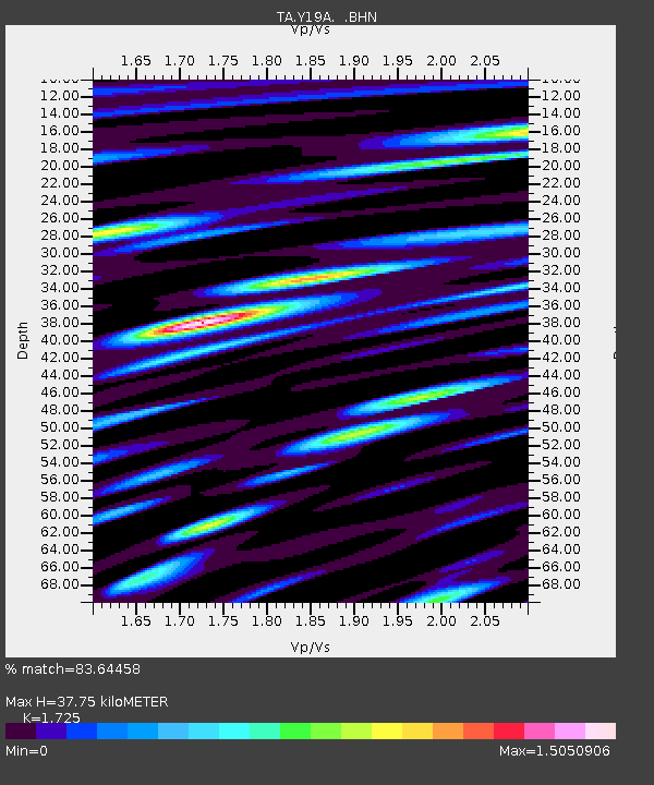
| Estimated Moho Depth: |
37.75 km |
| Estimated Crust Vp/Vs: |
1.73 |
| Assumed Crust Vp: |
6.276 km/s |
| Estimated Crust Vs: |
3.638 km/s |
| Estimated Crust Poisson's Ratio: |
0.25 |
|
| Radial Match: |
83.64458 % |
| Radial Bump: |
400 |
| Transverse Match: |
73.91909 % |
| Transverse Bump: |
400 |
| SOD ConfigId: |
2564 |
| Insert Time: |
2010-03-06 17:56:44.590 +0000 |
| GWidth: |
2.5 |
| Max Bumps: |
400 |
| Tol: |
0.001 |
|
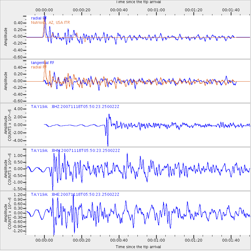
Signal To Noise
| Channel | StoN | STA | LTA |
| TA:Y19A: :BHN:20071118T05:50:23.250022Z | 3.2261136 | 4.4249745E-7 | 1.3716115E-7 |
| TA:Y19A: :BHE:20071118T05:50:23.250022Z | 2.2487636 | 3.5010413E-7 | 1.556874E-7 |
| TA:Y19A: :BHZ:20071118T05:50:23.250022Z | 11.80925 | 1.636576E-6 | 1.3858426E-7 |
| Arrivals |
| Ps | 4.5 SECOND |
| PpPs | 16 SECOND |
| PsPs/PpSs | 20 SECOND |


