You are here: Home > Network List > TA - USArray Transportable Network (new EarthScope stations) Stations List
> Station Y19A Nutrioso, AZ, USA > Earthquake Result Viewer
Y19A Nutrioso, AZ, USA - Earthquake Result Viewer
| Earthquake location: |
Volcano Islands, Japan Region |
| Earthquake latitude/longitude: |
22.0/142.7 |
| Earthquake time(UTC): |
2007/09/28 (271) 13:38:59 GMT |
| Earthquake Depth: |
276 km |
| Earthquake Magnitude: |
6.7 MB, 7.4 MW, 7.4 MW |
| Earthquake Catalog/Contributor: |
WHDF/NEIC |
|
| Network: |
TA USArray Transportable Network (new EarthScope stations) |
| Station: |
Y19A Nutrioso, AZ, USA |
| Lat/Lon: |
33.96 N/109.25 W |
| Elevation: |
2448 m |
|
| Distance: |
91.9 deg |
| Az: |
52.232 deg |
| Baz: |
298.043 deg |
| Ray Param: |
0.041397512 |
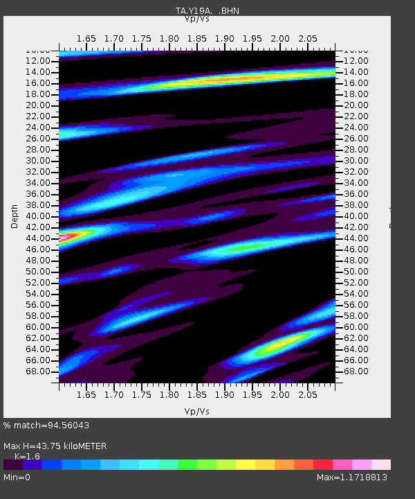
| Estimated Moho Depth: |
43.75 km |
| Estimated Crust Vp/Vs: |
1.60 |
| Assumed Crust Vp: |
6.276 km/s |
| Estimated Crust Vs: |
3.922 km/s |
| Estimated Crust Poisson's Ratio: |
0.18 |
|
| Radial Match: |
94.56043 % |
| Radial Bump: |
400 |
| Transverse Match: |
82.83711 % |
| Transverse Bump: |
400 |
| SOD ConfigId: |
2564 |
| Insert Time: |
2010-03-06 17:56:58.687 +0000 |
| GWidth: |
2.5 |
| Max Bumps: |
400 |
| Tol: |
0.001 |
|

Signal To Noise
| Channel | StoN | STA | LTA |
| TA:Y19A: :BHN:20070928T13:51:05.125012Z | 10.503287 | 1.0766339E-6 | 1.0250448E-7 |
| TA:Y19A: :BHE:20070928T13:51:05.125012Z | 19.93202 | 1.8860289E-6 | 9.462307E-8 |
| TA:Y19A: :BHZ:20070928T13:51:05.125012Z | 67.68488 | 7.245016E-6 | 1.07040385E-7 |
| Arrivals |
| Ps | 4.3 SECOND |
| PpPs | 18 SECOND |
| PsPs/PpSs | 22 SECOND |


