You are here: Home > Network List > TA - USArray Transportable Network (new EarthScope stations) Stations List
> Station Y19A Nutrioso, AZ, USA > Earthquake Result Viewer
Y19A Nutrioso, AZ, USA - Earthquake Result Viewer

| Earthquake location: |
Santa Cruz Islands |
| Earthquake latitude/longitude: |
-11.6/165.8 |
| Earthquake time(UTC): |
2007/09/02 (245) 01:05:18 GMT |
| Earthquake Depth: |
35 km |
| Earthquake Magnitude: |
5.9 MB, 7.3 MS, 7.2 MW, 6.9 ME |
| Earthquake Catalog/Contributor: |
WHDF/NEIC |
|
| Network: |
TA USArray Transportable Network (new EarthScope stations) |
| Station: |
Y19A Nutrioso, AZ, USA |
| Lat/Lon: |
33.96 N/109.25 W |
| Elevation: |
2448 m |
|
| Distance: |
92.3 deg |
| Az: |
55.962 deg |
| Baz: |
257.643 deg |
| Ray Param: |
0.041471355 |
| Estimated Moho Depth: |
41.5 km |
| Estimated Crust Vp/Vs: |
1.73 |
| Assumed Crust Vp: |
6.276 km/s |
| Estimated Crust Vs: |
3.622 km/s |
| Estimated Crust Poisson's Ratio: |
0.25 |
|
| Radial Match: |
97.85246 % |
| Radial Bump: |
309 |
| Transverse Match: |
84.03195 % |
| Transverse Bump: |
400 |
| SOD ConfigId: |
2564 |
| Insert Time: |
2010-03-06 17:57:06.621 +0000 |
| GWidth: |
2.5 |
| Max Bumps: |
400 |
| Tol: |
0.001 |
|
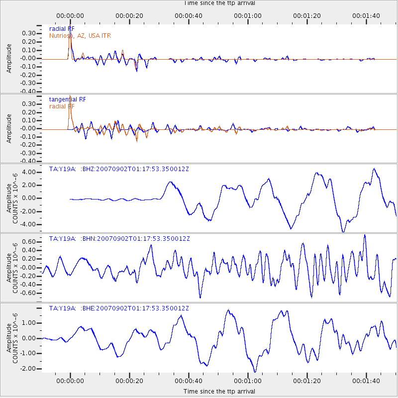
Signal To Noise
| Channel | StoN | STA | LTA |
| TA:Y19A: :BHN:20070902T01:17:53.350012Z | 1.6403679 | 1.6177837E-7 | 9.862323E-8 |
| TA:Y19A: :BHE:20070902T01:17:53.350012Z | 9.56058 | 5.258459E-7 | 5.500146E-8 |
| TA:Y19A: :BHZ:20070902T01:17:53.350012Z | 18.195856 | 1.6588973E-6 | 9.1168964E-8 |
| Arrivals |
| Ps | 4.9 SECOND |
| PpPs | 18 SECOND |
| PsPs/PpSs | 23 SECOND |


