You are here: Home > Network List > TA - USArray Transportable Network (new EarthScope stations) Stations List
> Station Y19A Nutrioso, AZ, USA > Earthquake Result Viewer
Y19A Nutrioso, AZ, USA - Earthquake Result Viewer

| Earthquake location: |
South Of Fiji Islands |
| Earthquake latitude/longitude: |
-26.3/-177.7 |
| Earthquake time(UTC): |
2007/07/18 (199) 00:07:35 GMT |
| Earthquake Depth: |
10 km |
| Earthquake Magnitude: |
5.8 MB, 5.9 MS, 6.1 MW, 6.0 MW |
| Earthquake Catalog/Contributor: |
WHDF/NEIC |
|
| Network: |
TA USArray Transportable Network (new EarthScope stations) |
| Station: |
Y19A Nutrioso, AZ, USA |
| Lat/Lon: |
33.96 N/109.25 W |
| Elevation: |
2448 m |
|
| Distance: |
88.4 deg |
| Az: |
50.677 deg |
| Baz: |
236.667 deg |
| Ray Param: |
0.04264762 |
| Estimated Moho Depth: |
31.25 km |
| Estimated Crust Vp/Vs: |
1.96 |
| Assumed Crust Vp: |
6.276 km/s |
| Estimated Crust Vs: |
3.206 km/s |
| Estimated Crust Poisson's Ratio: |
0.32 |
|
| Radial Match: |
89.92615 % |
| Radial Bump: |
400 |
| Transverse Match: |
80.832375 % |
| Transverse Bump: |
400 |
| SOD ConfigId: |
2564 |
| Insert Time: |
2010-03-06 17:57:25.262 +0000 |
| GWidth: |
2.5 |
| Max Bumps: |
400 |
| Tol: |
0.001 |
|
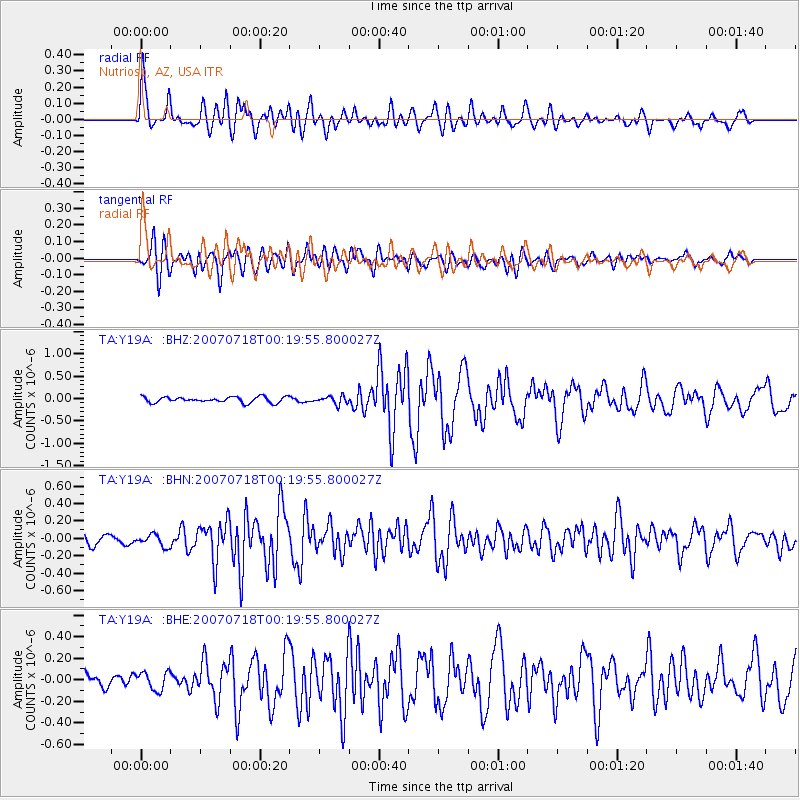
Signal To Noise
| Channel | StoN | STA | LTA |
| TA:Y19A: :BHN:20070718T00:19:55.800027Z | 1.1853157 | 6.997894E-8 | 5.903823E-8 |
| TA:Y19A: :BHE:20070718T00:19:55.800027Z | 1.4337204 | 8.372009E-8 | 5.83936E-8 |
| TA:Y19A: :BHZ:20070718T00:19:55.800027Z | 1.3921454 | 8.797397E-8 | 6.319309E-8 |
| Arrivals |
| Ps | 4.9 SECOND |
| PpPs | 14 SECOND |
| PsPs/PpSs | 19 SECOND |


