You are here: Home > Network List > CI - Caltech Regional Seismic Network Stations List
> Station MPM Manuel Prospect Mine, California, USA > Earthquake Result Viewer
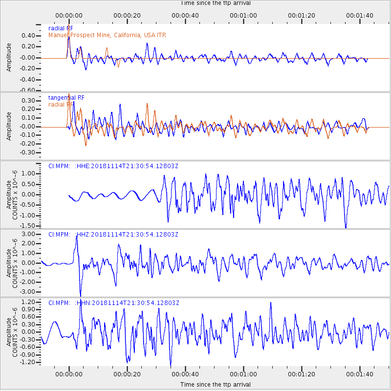
MPM Manuel Prospect Mine, California, USA - Earthquake Result Viewer
*The percent match for this event was below the threshold and hence no stack was calculated.
| Earthquake location: |
Near East Coast Of Kamchatka |
| Earthquake latitude/longitude: |
55.6/162.0 |
| Earthquake time(UTC): |
2018/11/14 (318) 21:21:50 GMT |
| Earthquake Depth: |
50 km |
| Earthquake Magnitude: |
6.1 Mww |
| Earthquake Catalog/Contributor: |
NEIC PDE/us |
|
| Network: |
CI Caltech Regional Seismic Network |
| Station: |
MPM Manuel Prospect Mine, California, USA |
| Lat/Lon: |
36.06 N/117.49 W |
| Elevation: |
185 m |
|
| Distance: |
56.1 deg |
| Az: |
74.457 deg |
| Baz: |
317.604 deg |
| Ray Param: |
$rayparam |
*The percent match for this event was below the threshold and hence was not used in the summary stack. |
|
| Radial Match: |
73.322136 % |
| Radial Bump: |
400 |
| Transverse Match: |
67.24275 % |
| Transverse Bump: |
400 |
| SOD ConfigId: |
13570011 |
| Insert Time: |
2019-05-01 19:42:30.374 +0000 |
| GWidth: |
2.5 |
| Max Bumps: |
400 |
| Tol: |
0.001 |
|
Signal To Noise
| Channel | StoN | STA | LTA |
| CI:MPM: :HHZ:20181114T21:30:54.12803Z | 5.6728673 | 1.4730188E-6 | 2.5966037E-7 |
| CI:MPM: :HHN:20181114T21:30:54.12803Z | 2.1739564 | 4.5222237E-7 | 2.0801814E-7 |
| CI:MPM: :HHE:20181114T21:30:54.12803Z | 3.8131707 | 5.0923006E-7 | 1.3354504E-7 |
| Arrivals |
| Ps | |
| PpPs | |
| PsPs/PpSs | |


