Y19A Nutrioso, AZ, USA - Earthquake Result Viewer
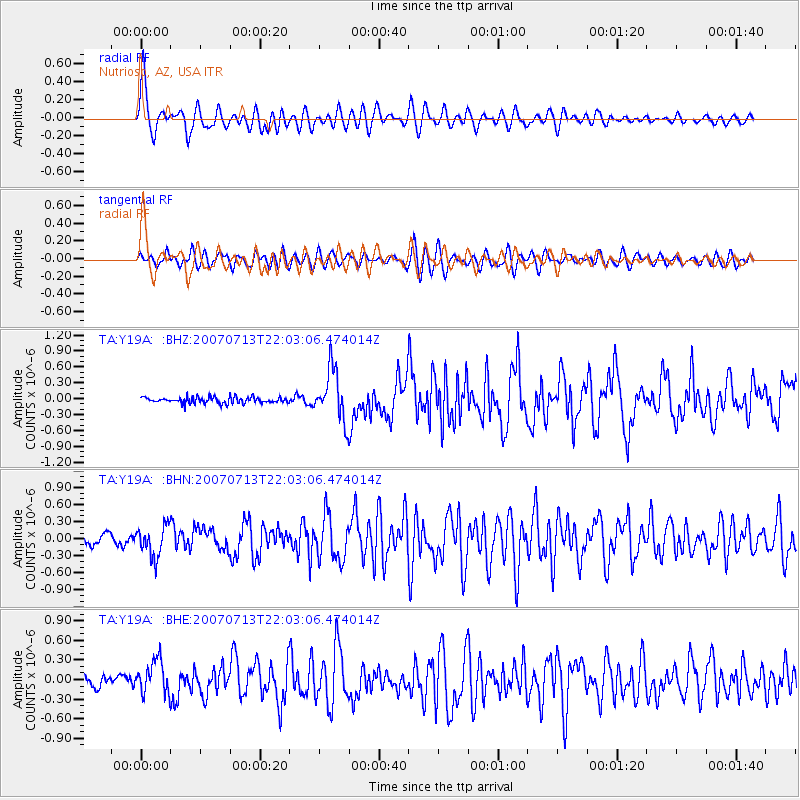
Earthquake location: Andreanof Islands, Aleutian Is.
Earthquake latitude/longitude: 51.8/-176.3
Earthquake time(UTC): 2007/07/13 (194) 21:54:43 GMT
Earthquake Depth: 35 km
Earthquake Magnitude: 5.7 MB, 5.6 MS, 6.0 MW, 5.9 MW
Earthquake Catalog/Contributor: WHDF/NEIC
Network: TA USArray Transportable Network (new EarthScope stations)
Station: Y19A Nutrioso, AZ, USA
Lat/Lon: 33.96 N/109.25 W
Elevation: 2448 m
Distance: 50.4 deg
Az: 83.253 deg
Baz: 312.158 deg
Ray Param: 0.06800675
Estimated Moho Depth: 28.0 km
Estimated Crust Vp/Vs: 2.10
Assumed Crust Vp: 6.276 km/s
Estimated Crust Vs: 2.992 km/s
Estimated Crust Poisson's Ratio: 0.35
Radial Match: 89.21686 %
Radial Bump: 400
Transverse Match: 65.57557 %
Transverse Bump: 400
SOD ConfigId: 2564
Insert Time: 2010-03-06 17:57:37.606 +0000
GWidth: 2.5
Max Bumps: 400
Tol: 0.001

Signal To Noise

ChannelStoNSTALTA
TA:Y19A: :BHN:20070713T22:03:06.474014Z3.61775922.6332097E-77.278565E-8
TA:Y19A: :BHE:20070713T22:03:06.474014Z3.60798622.6564047E-77.3625685E-8
TA:Y19A: :BHZ:20070713T22:03:06.474014Z8.732984.796113E-75.4919546E-8
Arrivals
Ps5.1 SECOND
PpPs13 SECOND
PsPs/PpSs18 SECOND