You are here: Home > Network List > RV - Regional Alberta Seismic Observatory for Earthquake Studies Network Stations List
> Station STPRA Salt Prairie Lookout Tower, AB > Earthquake Result Viewer
STPRA Salt Prairie Lookout Tower, AB - Earthquake Result Viewer
| Earthquake location: |
Near East Coast Of Kamchatka |
| Earthquake latitude/longitude: |
55.6/162.0 |
| Earthquake time(UTC): |
2018/11/14 (318) 21:21:50 GMT |
| Earthquake Depth: |
50 km |
| Earthquake Magnitude: |
6.1 Mww |
| Earthquake Catalog/Contributor: |
NEIC PDE/us |
|
| Network: |
RV Regional Alberta Seismic Observatory for Earthquake Studies Network |
| Station: |
STPRA Salt Prairie Lookout Tower, AB |
| Lat/Lon: |
55.66 N/115.83 W |
| Elevation: |
761 m |
|
| Distance: |
43.7 deg |
| Az: |
54.284 deg |
| Baz: |
305.658 deg |
| Ray Param: |
0.072214246 |
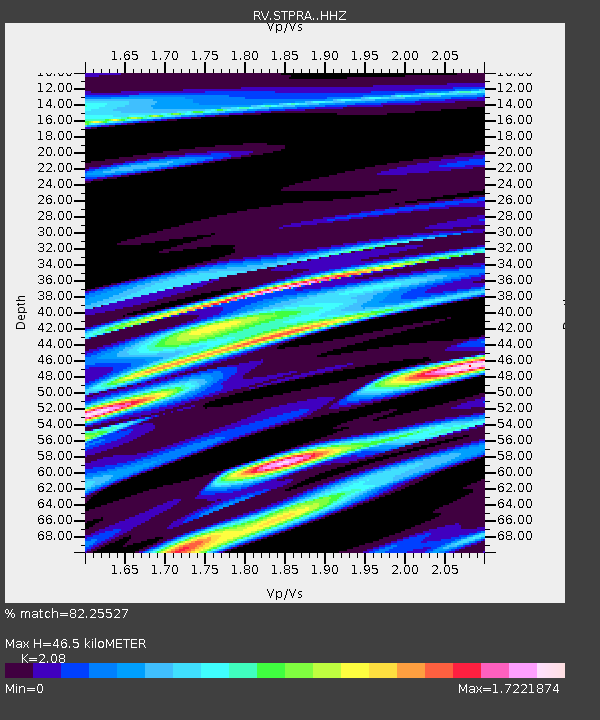
| Estimated Moho Depth: |
46.5 km |
| Estimated Crust Vp/Vs: |
2.08 |
| Assumed Crust Vp: |
6.483 km/s |
| Estimated Crust Vs: |
3.117 km/s |
| Estimated Crust Poisson's Ratio: |
0.35 |
|
| Radial Match: |
82.25527 % |
| Radial Bump: |
400 |
| Transverse Match: |
52.74416 % |
| Transverse Bump: |
400 |
| SOD ConfigId: |
13570011 |
| Insert Time: |
2019-05-01 19:50:37.980 +0000 |
| GWidth: |
2.5 |
| Max Bumps: |
400 |
| Tol: |
0.001 |
|

Signal To Noise
| Channel | StoN | STA | LTA |
| RV:STPRA: :HHZ:20181114T21:29:20.919991Z | 6.4696546 | 2.7842568E-6 | 4.3035635E-7 |
| RV:STPRA: :HHN:20181114T21:29:20.919991Z | 2.1263614 | 1.6142785E-6 | 7.5917416E-7 |
| RV:STPRA: :HHE:20181114T21:29:20.919991Z | 2.0576024 | 2.041052E-6 | 9.919565E-7 |
| Arrivals |
| Ps | 8.2 SECOND |
| PpPs | 21 SECOND |
| PsPs/PpSs | 29 SECOND |


