You are here: Home > Network List > TA - USArray Transportable Network (new EarthScope stations) Stations List
> Station W19A Sanders, AZ, USA > Earthquake Result Viewer
W19A Sanders, AZ, USA - Earthquake Result Viewer
| Earthquake location: |
Southern Peru |
| Earthquake latitude/longitude: |
-16.0/-71.7 |
| Earthquake time(UTC): |
2008/07/08 (190) 09:13:07 GMT |
| Earthquake Depth: |
123 km |
| Earthquake Magnitude: |
5.8 MB, 6.2 MW, 6.2 MW |
| Earthquake Catalog/Contributor: |
WHDF/NEIC |
|
| Network: |
TA USArray Transportable Network (new EarthScope stations) |
| Station: |
W19A Sanders, AZ, USA |
| Lat/Lon: |
35.11 N/109.39 W |
| Elevation: |
1785 m |
|
| Distance: |
62.1 deg |
| Az: |
325.497 deg |
| Baz: |
138.353 deg |
| Ray Param: |
0.060083274 |
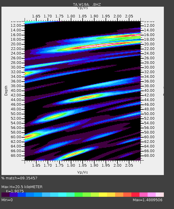
| Estimated Moho Depth: |
20.5 km |
| Estimated Crust Vp/Vs: |
1.91 |
| Assumed Crust Vp: |
6.496 km/s |
| Estimated Crust Vs: |
3.406 km/s |
| Estimated Crust Poisson's Ratio: |
0.31 |
|
| Radial Match: |
89.35457 % |
| Radial Bump: |
400 |
| Transverse Match: |
73.12288 % |
| Transverse Bump: |
400 |
| SOD ConfigId: |
2504 |
| Insert Time: |
2010-03-06 17:59:43.237 +0000 |
| GWidth: |
2.5 |
| Max Bumps: |
400 |
| Tol: |
0.001 |
|

Signal To Noise
| Channel | StoN | STA | LTA |
| TA:W19A: :BHZ:20080708T09:22:44.624001Z | 5.0245485 | 5.639952E-7 | 1.12247925E-7 |
| TA:W19A: :BHN:20080708T09:22:44.624001Z | 2.1656501 | 2.638858E-7 | 1.2185062E-7 |
| TA:W19A: :BHE:20080708T09:22:44.624001Z | 1.0386714 | 1.604942E-7 | 1.5451874E-7 |
| Arrivals |
| Ps | 3.0 SECOND |
| PpPs | 8.8 SECOND |
| PsPs/PpSs | 12 SECOND |


