You are here: Home > Network List > TA - USArray Transportable Network (new EarthScope stations) Stations List
> Station H31M Peel River, Yukon, CAN > Earthquake Result Viewer
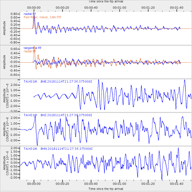
H31M Peel River, Yukon, CAN - Earthquake Result Viewer
*The percent match for this event was below the threshold and hence no stack was calculated.
| Earthquake location: |
Near East Coast Of Kamchatka |
| Earthquake latitude/longitude: |
55.6/162.0 |
| Earthquake time(UTC): |
2018/11/14 (318) 21:21:50 GMT |
| Earthquake Depth: |
50 km |
| Earthquake Magnitude: |
6.1 Mww |
| Earthquake Catalog/Contributor: |
NEIC PDE/us |
|
| Network: |
TA USArray Transportable Network (new EarthScope stations) |
| Station: |
H31M Peel River, Yukon, CAN |
| Lat/Lon: |
65.81 N/134.34 W |
| Elevation: |
642 m |
|
| Distance: |
31.3 deg |
| Az: |
45.256 deg |
| Baz: |
282.233 deg |
| Ray Param: |
$rayparam |
*The percent match for this event was below the threshold and hence was not used in the summary stack. |
|
| Radial Match: |
74.29632 % |
| Radial Bump: |
400 |
| Transverse Match: |
63.681557 % |
| Transverse Bump: |
400 |
| SOD ConfigId: |
13570011 |
| Insert Time: |
2019-05-01 19:51:00.646 +0000 |
| GWidth: |
2.5 |
| Max Bumps: |
400 |
| Tol: |
0.001 |
|
Signal To Noise
| Channel | StoN | STA | LTA |
| TA:H31M: :BHZ:20181114T21:27:36.375009Z | 6.019853 | 1.346144E-6 | 2.2361742E-7 |
| TA:H31M: :BHN:20181114T21:27:36.375009Z | 1.6976348 | 4.0981553E-7 | 2.4140382E-7 |
| TA:H31M: :BHE:20181114T21:27:36.375009Z | 4.6135693 | 1.316344E-6 | 2.8532008E-7 |
| Arrivals |
| Ps | |
| PpPs | |
| PsPs/PpSs | |


