You are here: Home > Network List > TA - USArray Transportable Network (new EarthScope stations) Stations List
> Station G31M Satah River, YT, CAN > Earthquake Result Viewer
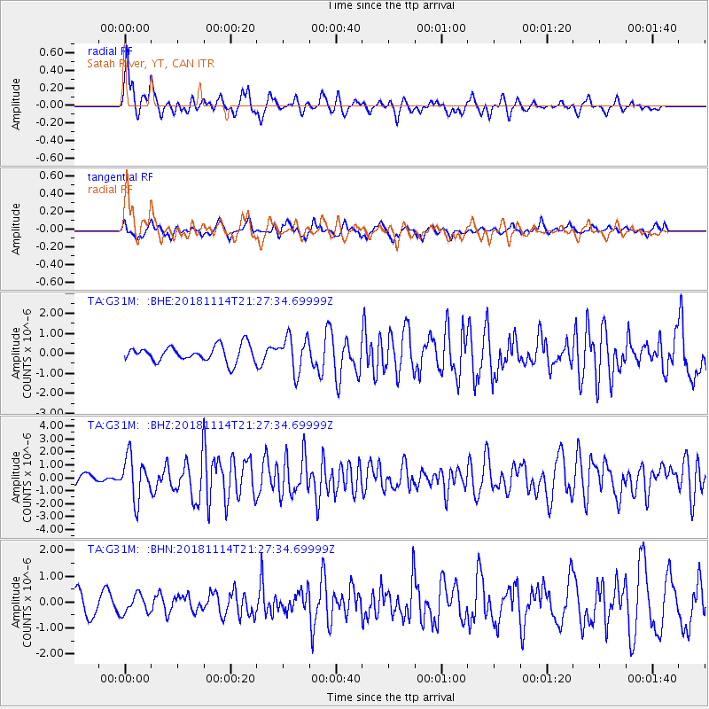
G31M Satah River, YT, CAN - Earthquake Result Viewer
*The percent match for this event was below the threshold and hence no stack was calculated.
| Earthquake location: |
Near East Coast Of Kamchatka |
| Earthquake latitude/longitude: |
55.6/162.0 |
| Earthquake time(UTC): |
2018/11/14 (318) 21:21:50 GMT |
| Earthquake Depth: |
50 km |
| Earthquake Magnitude: |
6.1 Mww |
| Earthquake Catalog/Contributor: |
NEIC PDE/us |
|
| Network: |
TA USArray Transportable Network (new EarthScope stations) |
| Station: |
G31M Satah River, YT, CAN |
| Lat/Lon: |
66.92 N/134.27 W |
| Elevation: |
61 m |
|
| Distance: |
31.1 deg |
| Az: |
43.122 deg |
| Baz: |
280.474 deg |
| Ray Param: |
$rayparam |
*The percent match for this event was below the threshold and hence was not used in the summary stack. |
|
| Radial Match: |
73.30032 % |
| Radial Bump: |
400 |
| Transverse Match: |
66.92675 % |
| Transverse Bump: |
400 |
| SOD ConfigId: |
13570011 |
| Insert Time: |
2019-05-01 19:51:01.010 +0000 |
| GWidth: |
2.5 |
| Max Bumps: |
400 |
| Tol: |
0.001 |
|
Signal To Noise
| Channel | StoN | STA | LTA |
| TA:G31M: :BHZ:20181114T21:27:34.69999Z | 3.6532965 | 1.654302E-6 | 4.5282448E-7 |
| TA:G31M: :BHN:20181114T21:27:34.69999Z | 1.0679113 | 3.6050608E-7 | 3.3758056E-7 |
| TA:G31M: :BHE:20181114T21:27:34.69999Z | 2.2177744 | 8.8064786E-7 | 3.9708635E-7 |
| Arrivals |
| Ps | |
| PpPs | |
| PsPs/PpSs | |


