You are here: Home > Network List > TA - USArray Transportable Network (new EarthScope stations) Stations List
> Station M30M Minto, Yukon, CA > Earthquake Result Viewer
M30M Minto, Yukon, CA - Earthquake Result Viewer
| Earthquake location: |
Near East Coast Of Kamchatka |
| Earthquake latitude/longitude: |
55.6/162.0 |
| Earthquake time(UTC): |
2018/11/14 (318) 21:21:50 GMT |
| Earthquake Depth: |
50 km |
| Earthquake Magnitude: |
6.1 Mww |
| Earthquake Catalog/Contributor: |
NEIC PDE/us |
|
| Network: |
TA USArray Transportable Network (new EarthScope stations) |
| Station: |
M30M Minto, Yukon, CA |
| Lat/Lon: |
62.58 N/136.79 W |
| Elevation: |
782 m |
|
| Distance: |
31.1 deg |
| Az: |
51.831 deg |
| Baz: |
285.654 deg |
| Ray Param: |
0.07910172 |
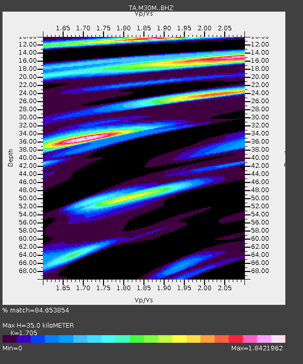
| Estimated Moho Depth: |
35.0 km |
| Estimated Crust Vp/Vs: |
1.71 |
| Assumed Crust Vp: |
6.566 km/s |
| Estimated Crust Vs: |
3.851 km/s |
| Estimated Crust Poisson's Ratio: |
0.24 |
|
| Radial Match: |
84.653854 % |
| Radial Bump: |
400 |
| Transverse Match: |
65.18802 % |
| Transverse Bump: |
400 |
| SOD ConfigId: |
13570011 |
| Insert Time: |
2019-05-01 19:51:07.036 +0000 |
| GWidth: |
2.5 |
| Max Bumps: |
400 |
| Tol: |
0.001 |
|

Signal To Noise
| Channel | StoN | STA | LTA |
| TA:M30M: :BHZ:20181114T21:27:34.100015Z | 8.628307 | 1.8121501E-6 | 2.1002384E-7 |
| TA:M30M: :BHN:20181114T21:27:34.100015Z | 2.3362741 | 5.234541E-7 | 2.240551E-7 |
| TA:M30M: :BHE:20181114T21:27:34.100015Z | 4.773678 | 1.1471387E-6 | 2.4030504E-7 |
| Arrivals |
| Ps | 4.1 SECOND |
| PpPs | 13 SECOND |
| PsPs/PpSs | 17 SECOND |


