You are here: Home > Network List > TA - USArray Transportable Network (new EarthScope stations) Stations List
> Station W19A Sanders, AZ, USA > Earthquake Result Viewer
W19A Sanders, AZ, USA - Earthquake Result Viewer
| Earthquake location: |
Fiji Islands Region |
| Earthquake latitude/longitude: |
-17.3/-177.3 |
| Earthquake time(UTC): |
2008/07/19 (201) 22:39:52 GMT |
| Earthquake Depth: |
391 km |
| Earthquake Magnitude: |
5.9 MB, 6.4 MW, 6.4 MW |
| Earthquake Catalog/Contributor: |
WHDF/NEIC |
|
| Network: |
TA USArray Transportable Network (new EarthScope stations) |
| Station: |
W19A Sanders, AZ, USA |
| Lat/Lon: |
35.11 N/109.39 W |
| Elevation: |
1785 m |
|
| Distance: |
82.8 deg |
| Az: |
49.971 deg |
| Baz: |
243.135 deg |
| Ray Param: |
0.045560487 |
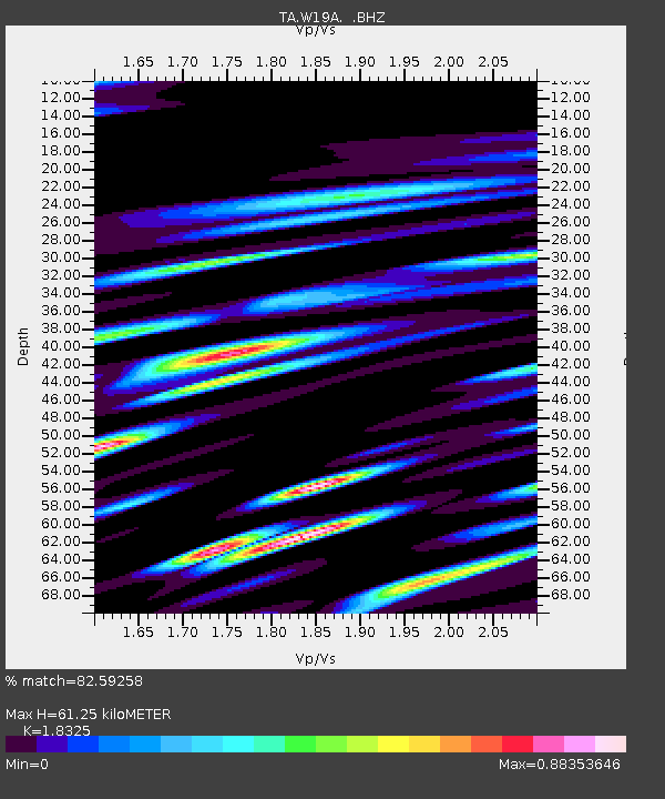
| Estimated Moho Depth: |
61.25 km |
| Estimated Crust Vp/Vs: |
1.83 |
| Assumed Crust Vp: |
6.496 km/s |
| Estimated Crust Vs: |
3.545 km/s |
| Estimated Crust Poisson's Ratio: |
0.29 |
|
| Radial Match: |
82.59258 % |
| Radial Bump: |
400 |
| Transverse Match: |
73.84081 % |
| Transverse Bump: |
400 |
| SOD ConfigId: |
2504 |
| Insert Time: |
2010-03-06 17:59:47.940 +0000 |
| GWidth: |
2.5 |
| Max Bumps: |
400 |
| Tol: |
0.001 |
|
Signal To Noise
| Channel | StoN | STA | LTA |
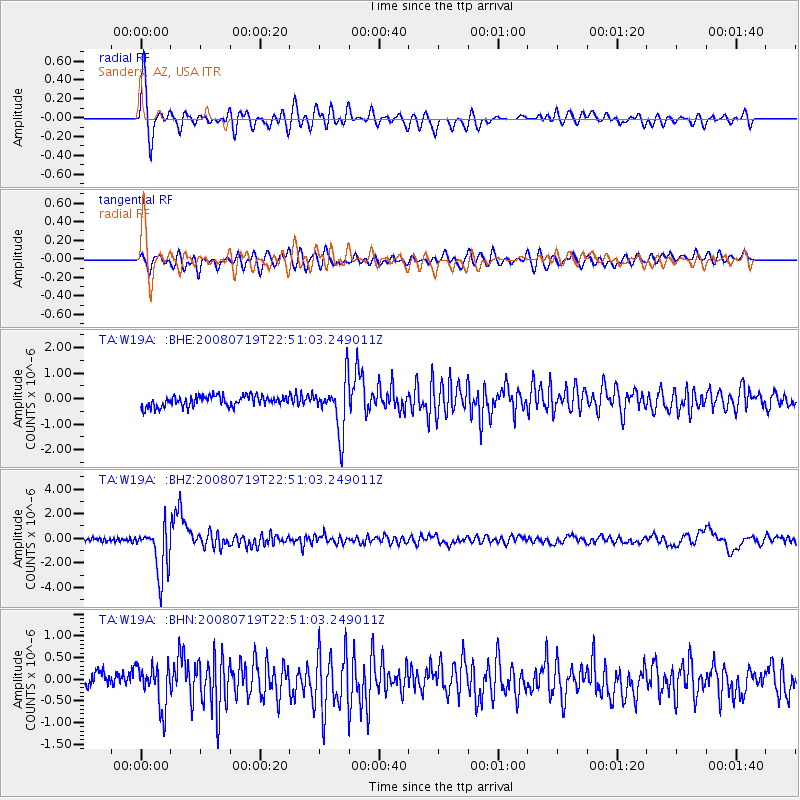
| TA:W19A: :BHZ:20080719T22:51:03.249011Z | 13.984882 | 2.0052587E-6 | 1.433876E-7 |
| TA:W19A: :BHN:20080719T22:51:03.249011Z | 1.8735948 | 4.7293491E-7 | 2.5242113E-7 |
| TA:W19A: :BHE:20080719T22:51:03.249011Z | 4.817834 | 1.0079355E-6 | 2.0920925E-7 |
| Arrivals |
| Ps | 8.0 SECOND |
| PpPs | 26 SECOND |
| PsPs/PpSs | 34 SECOND |


