You are here: Home > Network List > TA - USArray Transportable Network (new EarthScope stations) Stations List
> Station N31M Braeburn, Yukon, CA > Earthquake Result Viewer
N31M Braeburn, Yukon, CA - Earthquake Result Viewer
| Earthquake location: |
Near East Coast Of Kamchatka |
| Earthquake latitude/longitude: |
55.6/162.0 |
| Earthquake time(UTC): |
2018/11/14 (318) 21:21:50 GMT |
| Earthquake Depth: |
50 km |
| Earthquake Magnitude: |
6.1 Mww |
| Earthquake Catalog/Contributor: |
NEIC PDE/us |
|
| Network: |
TA USArray Transportable Network (new EarthScope stations) |
| Station: |
N31M Braeburn, Yukon, CA |
| Lat/Lon: |
61.49 N/135.78 W |
| Elevation: |
716 m |
|
| Distance: |
31.8 deg |
| Az: |
53.572 deg |
| Baz: |
288.033 deg |
| Ray Param: |
0.07880057 |
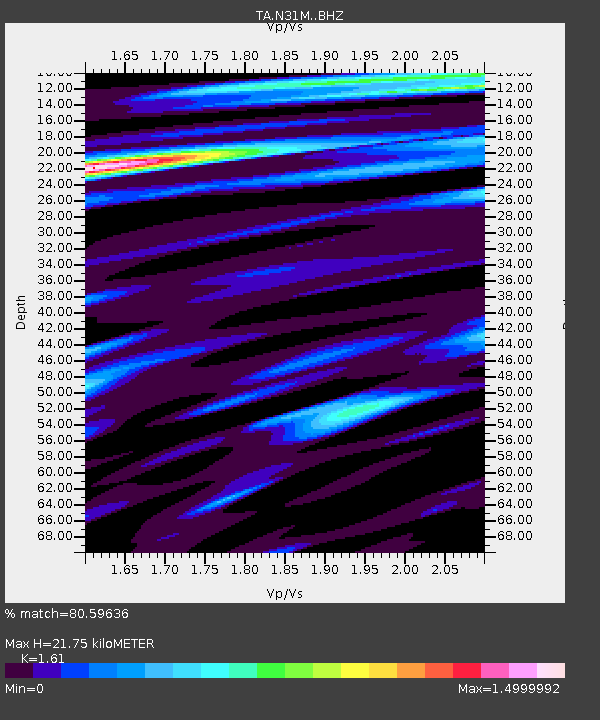
| Estimated Moho Depth: |
21.75 km |
| Estimated Crust Vp/Vs: |
1.61 |
| Assumed Crust Vp: |
6.419 km/s |
| Estimated Crust Vs: |
3.987 km/s |
| Estimated Crust Poisson's Ratio: |
0.19 |
|
| Radial Match: |
80.59636 % |
| Radial Bump: |
400 |
| Transverse Match: |
63.444878 % |
| Transverse Bump: |
400 |
| SOD ConfigId: |
13570011 |
| Insert Time: |
2019-05-01 19:51:09.899 +0000 |
| GWidth: |
2.5 |
| Max Bumps: |
400 |
| Tol: |
0.001 |
|

Signal To Noise
| Channel | StoN | STA | LTA |
| TA:N31M: :BHZ:20181114T21:27:40.875009Z | 7.994042 | 1.6709862E-6 | 2.0902894E-7 |
| TA:N31M: :BHN:20181114T21:27:40.875009Z | 0.94591725 | 2.3929968E-7 | 2.529816E-7 |
| TA:N31M: :BHE:20181114T21:27:40.875009Z | 2.5804539 | 7.847441E-7 | 3.041109E-7 |
| Arrivals |
| Ps | 2.3 SECOND |
| PpPs | 8.1 SECOND |
| PsPs/PpSs | 10 SECOND |


