You are here: Home > Network List > TA - USArray Transportable Network (new EarthScope stations) Stations List
> Station P32M Atlin, BC, CAN > Earthquake Result Viewer
P32M Atlin, BC, CAN - Earthquake Result Viewer
| Earthquake location: |
Near East Coast Of Kamchatka |
| Earthquake latitude/longitude: |
55.6/162.0 |
| Earthquake time(UTC): |
2018/11/14 (318) 21:21:50 GMT |
| Earthquake Depth: |
50 km |
| Earthquake Magnitude: |
6.1 Mww |
| Earthquake Catalog/Contributor: |
NEIC PDE/us |
|
| Network: |
TA USArray Transportable Network (new EarthScope stations) |
| Station: |
P32M Atlin, BC, CAN |
| Lat/Lon: |
59.59 N/133.71 W |
| Elevation: |
793 m |
|
| Distance: |
33.5 deg |
| Az: |
56.236 deg |
| Baz: |
292.072 deg |
| Ray Param: |
0.07808854 |
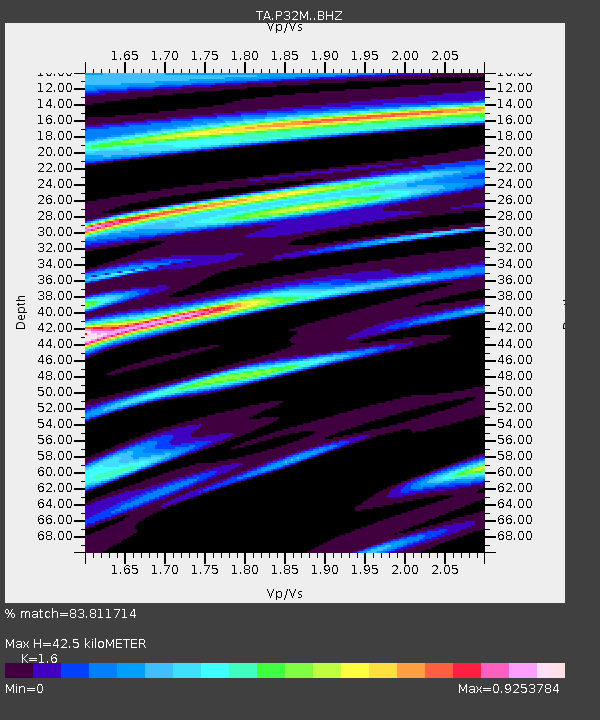
| Estimated Moho Depth: |
42.5 km |
| Estimated Crust Vp/Vs: |
1.60 |
| Assumed Crust Vp: |
6.597 km/s |
| Estimated Crust Vs: |
4.123 km/s |
| Estimated Crust Poisson's Ratio: |
0.18 |
|
| Radial Match: |
83.811714 % |
| Radial Bump: |
400 |
| Transverse Match: |
60.785126 % |
| Transverse Bump: |
400 |
| SOD ConfigId: |
13570011 |
| Insert Time: |
2019-05-01 19:51:14.939 +0000 |
| GWidth: |
2.5 |
| Max Bumps: |
400 |
| Tol: |
0.001 |
|
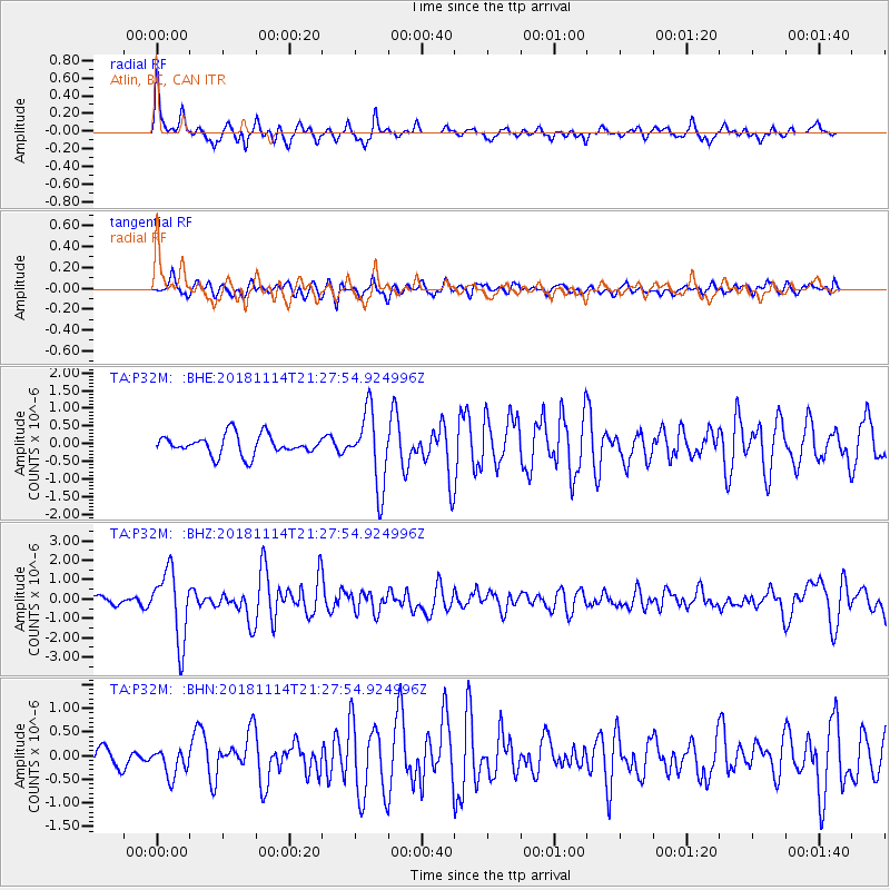
Signal To Noise
| Channel | StoN | STA | LTA |
| TA:P32M: :BHZ:20181114T21:27:54.924996Z | 5.2056656 | 1.7841909E-6 | 3.427402E-7 |
| TA:P32M: :BHN:20181114T21:27:54.924996Z | 1.6779718 | 2.996982E-7 | 1.7860742E-7 |
| TA:P32M: :BHE:20181114T21:27:54.924996Z | 3.736028 | 1.0456876E-6 | 2.7989287E-7 |
| Arrivals |
| Ps | 4.2 SECOND |
| PpPs | 15 SECOND |
| PsPs/PpSs | 20 SECOND |


