You are here: Home > Network List > TA - USArray Transportable Network (new EarthScope stations) Stations List
> Station R32K Eaglecrest, AK, USA > Earthquake Result Viewer
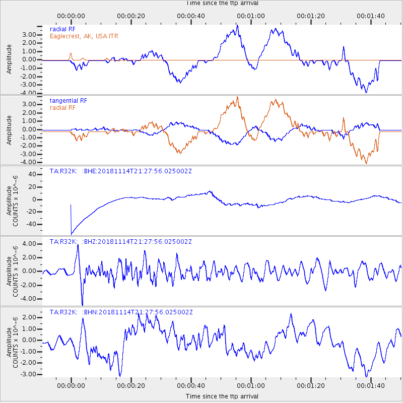
R32K Eaglecrest, AK, USA - Earthquake Result Viewer
*The percent match for this event was below the threshold and hence no stack was calculated.
| Earthquake location: |
Near East Coast Of Kamchatka |
| Earthquake latitude/longitude: |
55.6/162.0 |
| Earthquake time(UTC): |
2018/11/14 (318) 21:21:50 GMT |
| Earthquake Depth: |
50 km |
| Earthquake Magnitude: |
6.1 Mww |
| Earthquake Catalog/Contributor: |
NEIC PDE/us |
|
| Network: |
TA USArray Transportable Network (new EarthScope stations) |
| Station: |
R32K Eaglecrest, AK, USA |
| Lat/Lon: |
58.27 N/134.52 W |
| Elevation: |
386 m |
|
| Distance: |
33.6 deg |
| Az: |
58.731 deg |
| Baz: |
293.465 deg |
| Ray Param: |
$rayparam |
*The percent match for this event was below the threshold and hence was not used in the summary stack. |
|
| Radial Match: |
24.959042 % |
| Radial Bump: |
400 |
| Transverse Match: |
28.342363 % |
| Transverse Bump: |
400 |
| SOD ConfigId: |
13570011 |
| Insert Time: |
2019-05-01 19:51:20.484 +0000 |
| GWidth: |
2.5 |
| Max Bumps: |
400 |
| Tol: |
0.001 |
|
Signal To Noise
| Channel | StoN | STA | LTA |
| TA:R32K: :BHZ:20181114T21:27:56.025002Z | 4.5699654 | 2.0472621E-6 | 4.47982E-7 |
| TA:R32K: :BHN:20181114T21:27:56.025002Z | 1.269535 | 1.0835438E-6 | 8.5349666E-7 |
| TA:R32K: :BHE:20181114T21:27:56.025002Z | 0.7963 | 1.3861496E-5 | 1.740738E-5 |
| Arrivals |
| Ps | |
| PpPs | |
| PsPs/PpSs | |


