You are here: Home > Network List > TA - USArray Transportable Network (new EarthScope stations) Stations List
> Station T25A Trinidad, CO, USA > Earthquake Result Viewer
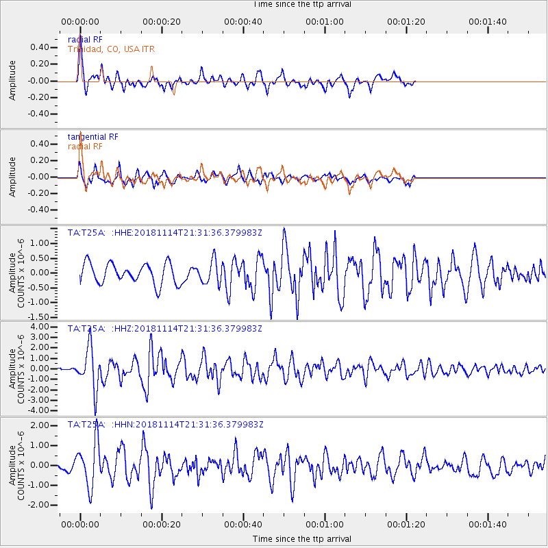
T25A Trinidad, CO, USA - Earthquake Result Viewer
*The percent match for this event was below the threshold and hence no stack was calculated.
| Earthquake location: |
Near East Coast Of Kamchatka |
| Earthquake latitude/longitude: |
55.6/162.0 |
| Earthquake time(UTC): |
2018/11/14 (318) 21:21:50 GMT |
| Earthquake Depth: |
50 km |
| Earthquake Magnitude: |
6.1 Mww |
| Earthquake Catalog/Contributor: |
NEIC PDE/us |
|
| Network: |
TA USArray Transportable Network (new EarthScope stations) |
| Station: |
T25A Trinidad, CO, USA |
| Lat/Lon: |
37.14 N/104.41 W |
| Elevation: |
2017 m |
|
| Distance: |
62.2 deg |
| Az: |
64.401 deg |
| Baz: |
320.21 deg |
| Ray Param: |
$rayparam |
*The percent match for this event was below the threshold and hence was not used in the summary stack. |
|
| Radial Match: |
73.82434 % |
| Radial Bump: |
400 |
| Transverse Match: |
76.00208 % |
| Transverse Bump: |
385 |
| SOD ConfigId: |
13570011 |
| Insert Time: |
2019-05-01 19:51:24.935 +0000 |
| GWidth: |
2.5 |
| Max Bumps: |
400 |
| Tol: |
0.001 |
|
Signal To Noise
| Channel | StoN | STA | LTA |
| TA:T25A: :HHZ:20181114T21:31:36.379983Z | 8.501066 | 2.0171422E-6 | 2.3728109E-7 |
| TA:T25A: :HHN:20181114T21:31:36.379983Z | 3.1831522 | 1.1596677E-6 | 3.6431422E-7 |
| TA:T25A: :HHE:20181114T21:31:36.379983Z | 1.149053 | 3.918598E-7 | 3.4102848E-7 |
| Arrivals |
| Ps | |
| PpPs | |
| PsPs/PpSs | |


