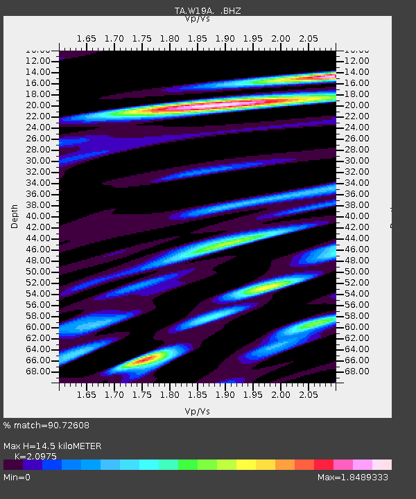
W19A Sanders, AZ, USA - Earthquake Result Viewer

Earthquake location: Andreanof Islands, Aleutian Is.
Earthquake latitude/longitude: 52.2/-175.7
Earthquake time(UTC): 2008/08/07 (220) 18:30:03 GMT
Earthquake Depth: 12 km
Earthquake Magnitude: 5.6 MB, 5.5 MS, 5.8 MW, 5.8 MW
Earthquake Catalog/Contributor: WHDF/NEIC
Network: TA USArray Transportable Network (new EarthScope stations)
Station: W19A Sanders, AZ, USA
Lat/Lon: 35.11 N/109.39 W
Elevation: 1785 m
Distance: 49.1 deg
Az: 82.979 deg
Baz: 311.818 deg
Ray Param: 0.06889644
Estimated Moho Depth: 14.5 km
Estimated Crust Vp/Vs: 2.10
Assumed Crust Vp: 6.496 km/s
Estimated Crust Vs: 3.097 km/s
Estimated Crust Poisson's Ratio: 0.35
Radial Match: 90.72608 %
Radial Bump: 400
Transverse Match: 81.91927 %
Transverse Bump: 400
SOD ConfigId: 2504
Insert Time: 2010-03-06 17:59:55.272 +0000
GWidth: 2.5
Max Bumps: 400
Tol: 0.001

Signal To Noise

ChannelStoNSTALTA
TA:W19A: :BHZ:20080807T18:38:19.498986Z7.10544824.1968298E-75.9064956E-8
TA:W19A: :BHN:20080807T18:38:19.498986Z1.65975181.3720522E-78.266611E-8
TA:W19A: :BHE:20080807T18:38:19.498986Z2.29798482.7413176E-71.1929224E-7
Arrivals
Ps2.6 SECOND
PpPs6.6 SECOND
PsPs/PpSs9.1 SECOND