You are here: Home > Network List > TA - USArray Transportable Network (new EarthScope stations) Stations List
> Station W19A Sanders, AZ, USA > Earthquake Result Viewer
W19A Sanders, AZ, USA - Earthquake Result Viewer
| Earthquake location: |
Peru-Brazil Border Region |
| Earthquake latitude/longitude: |
-7.6/-74.4 |
| Earthquake time(UTC): |
2008/08/26 (239) 21:00:36 GMT |
| Earthquake Depth: |
154 km |
| Earthquake Magnitude: |
6.0 MB, 6.4 MW, 6.4 MW |
| Earthquake Catalog/Contributor: |
WHDF/NEIC |
|
| Network: |
TA USArray Transportable Network (new EarthScope stations) |
| Station: |
W19A Sanders, AZ, USA |
| Lat/Lon: |
35.11 N/109.39 W |
| Elevation: |
1785 m |
|
| Distance: |
53.8 deg |
| Az: |
324.37 deg |
| Baz: |
135.223 deg |
| Ray Param: |
0.065326124 |
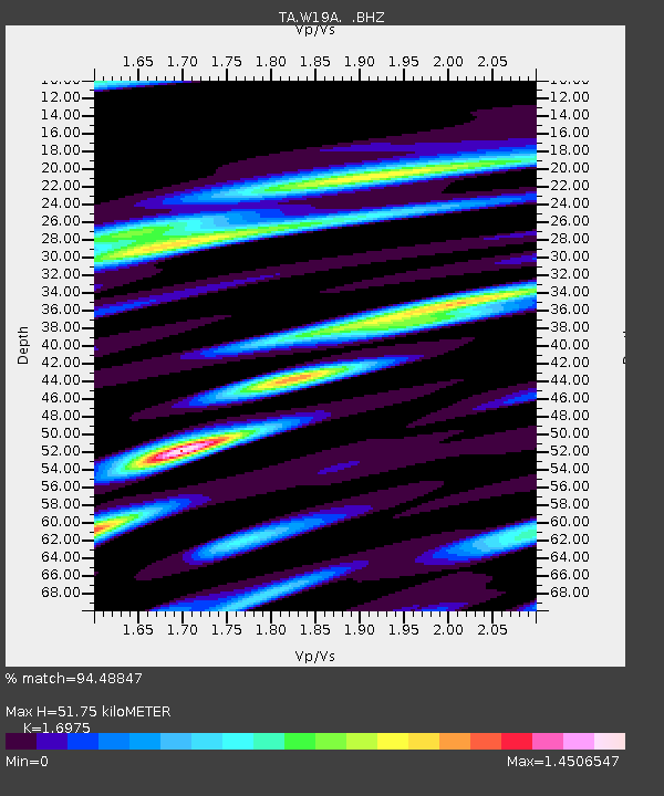
| Estimated Moho Depth: |
51.75 km |
| Estimated Crust Vp/Vs: |
1.70 |
| Assumed Crust Vp: |
6.496 km/s |
| Estimated Crust Vs: |
3.827 km/s |
| Estimated Crust Poisson's Ratio: |
0.23 |
|
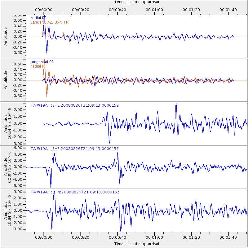
| Radial Match: |
94.48847 % |
| Radial Bump: |
398 |
| Transverse Match: |
79.77946 % |
| Transverse Bump: |
400 |
| SOD ConfigId: |
2504 |
| Insert Time: |
2010-03-06 18:00:01.216 +0000 |
| GWidth: |
2.5 |
| Max Bumps: |
400 |
| Tol: |
0.001 |
|
Signal To Noise
| Channel | StoN | STA | LTA |
| TA:W19A: :BHZ:20080826T21:09:13.000015Z | 24.316067 | 2.1127596E-6 | 8.68874E-8 |
| TA:W19A: :BHN:20080826T21:09:13.000015Z | 9.201281 | 9.210474E-7 | 1.0009991E-7 |
| TA:W19A: :BHE:20080826T21:09:13.000015Z | 5.3006215 | 6.634416E-7 | 1.2516298E-7 |
| Arrivals |
| Ps | 5.9 SECOND |
| PpPs | 20 SECOND |
| PsPs/PpSs | 26 SECOND |


