You are here: Home > Network List > TA - USArray Transportable Network (new EarthScope stations) Stations List
> Station W19A Sanders, AZ, USA > Earthquake Result Viewer
W19A Sanders, AZ, USA - Earthquake Result Viewer
| Earthquake location: |
Arctic Ocean |
| Earthquake latitude/longitude: |
79.8/-115.4 |
| Earthquake time(UTC): |
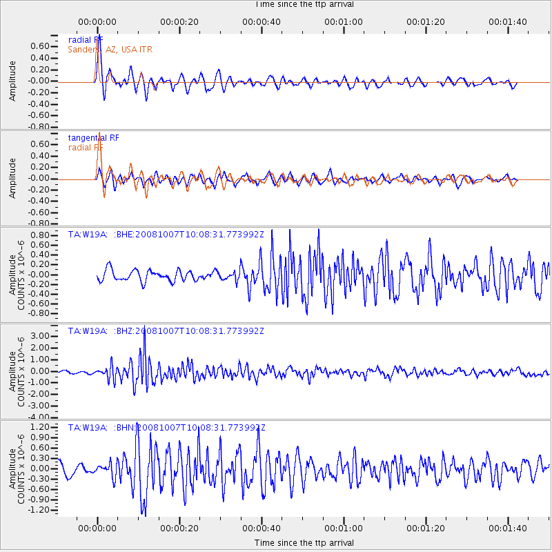
2008/10/07 (281) 10:00:48 GMT |
| Earthquake Depth: |
10 km |
| Earthquake Magnitude: |
5.6 MB, 5.5 MS, 5.7 MW, 5.7 MW |
| Earthquake Catalog/Contributor: |
WHDF/NEIC |
|
| Network: |
TA USArray Transportable Network (new EarthScope stations) |
| Station: |
W19A Sanders, AZ, USA |
| Lat/Lon: |
35.11 N/109.39 W |
| Elevation: |
1785 m |
|
| Distance: |
44.9 deg |
| Az: |
172.955 deg |
| Baz: |
358.475 deg |
| Ray Param: |
0.07164135 |
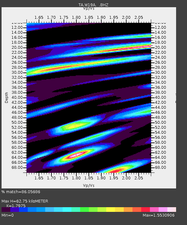
| Estimated Moho Depth: |
62.75 km |
| Estimated Crust Vp/Vs: |
1.80 |
| Assumed Crust Vp: |
6.496 km/s |
| Estimated Crust Vs: |
3.614 km/s |
| Estimated Crust Poisson's Ratio: |
0.28 |
|
| Radial Match: |
86.05686 % |
| Radial Bump: |
400 |
| Transverse Match: |
63.73794 % |
| Transverse Bump: |
400 |
| SOD ConfigId: |
2556 |
| Insert Time: |
2010-03-06 18:00:02.800 +0000 |
| GWidth: |
2.5 |
| Max Bumps: |
400 |
| Tol: |
0.001 |
|
Signal To Noise
| Channel | StoN | STA | LTA |
| TA:W19A: :BHZ:20081007T10:08:31.773992Z | 3.477019 | 5.421781E-7 | 1.5593187E-7 |
| TA:W19A: :BHN:20081007T10:08:31.773992Z | 1.3571689 | 1.953756E-7 | 1.439582E-7 |
| TA:W19A: :BHE:20081007T10:08:31.773992Z | 0.7939422 | 8.8270745E-8 | 1.1118031E-7 |
| Arrivals |
| Ps | 8.2 SECOND |
| PpPs | 25 SECOND |
| PsPs/PpSs | 34 SECOND |


