You are here: Home > Network List > TA - USArray Transportable Network (new EarthScope stations) Stations List
> Station W19A Sanders, AZ, USA > Earthquake Result Viewer
W19A Sanders, AZ, USA - Earthquake Result Viewer
| Earthquake location: |
Chile-Bolivia Border Region |
| Earthquake latitude/longitude: |
-20.0/-69.0 |
| Earthquake time(UTC): |
2008/03/24 (084) 20:39:07 GMT |
| Earthquake Depth: |
120 km |
| Earthquake Magnitude: |
5.7 MB, 6.2 MW, 6.1 MW |
| Earthquake Catalog/Contributor: |
WHDF/NEIC |
|
| Network: |
TA USArray Transportable Network (new EarthScope stations) |
| Station: |
W19A Sanders, AZ, USA |
| Lat/Lon: |
35.11 N/109.39 W |
| Elevation: |
1785 m |
|
| Distance: |
66.9 deg |
| Az: |
324.704 deg |
| Baz: |
138.502 deg |
| Ray Param: |
0.056960776 |
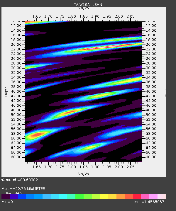
| Estimated Moho Depth: |
20.75 km |
| Estimated Crust Vp/Vs: |
1.95 |
| Assumed Crust Vp: |
6.496 km/s |
| Estimated Crust Vs: |
3.34 km/s |
| Estimated Crust Poisson's Ratio: |
0.32 |
|
| Radial Match: |
83.63382 % |
| Radial Bump: |
400 |
| Transverse Match: |
69.480156 % |
| Transverse Bump: |
400 |
| SOD ConfigId: |
2564 |
| Insert Time: |
2010-03-06 18:00:19.695 +0000 |
| GWidth: |
2.5 |
| Max Bumps: |
400 |
| Tol: |
0.001 |
|

Signal To Noise
| Channel | StoN | STA | LTA |
| TA:W19A: :BHN:20080324T20:49:16.424006Z | 2.8750975 | 4.510343E-7 | 1.5687618E-7 |
| TA:W19A: :BHE:20080324T20:49:16.424006Z | 2.0931714 | 3.36358E-7 | 1.60693E-7 |
| TA:W19A: :BHZ:20080324T20:49:16.424006Z | 6.79563 | 9.3827293E-7 | 1.3807005E-7 |
| Arrivals |
| Ps | 3.1 SECOND |
| PpPs | 9.1 SECOND |
| PsPs/PpSs | 12 SECOND |


