You are here: Home > Network List > TA - USArray Transportable Network (new EarthScope stations) Stations List
> Station W19A Sanders, AZ, USA > Earthquake Result Viewer
W19A Sanders, AZ, USA - Earthquake Result Viewer

| Earthquake location: |
Costa Rica |
| Earthquake latitude/longitude: |
10.2/-84.2 |
| Earthquake time(UTC): |
2009/01/08 (008) 19:21:35 GMT |
| Earthquake Depth: |
14 km |
| Earthquake Magnitude: |
5.7 MB, 6.0 MS, 6.1 MW, 6.1 MW |
| Earthquake Catalog/Contributor: |
WHDF/NEIC |
|
| Network: |
TA USArray Transportable Network (new EarthScope stations) |
| Station: |
W19A Sanders, AZ, USA |
| Lat/Lon: |
35.11 N/109.39 W |
| Elevation: |
1785 m |
|
| Distance: |
33.8 deg |
| Az: |
321.176 deg |
| Baz: |
131.162 deg |
| Ray Param: |
0.07802251 |
| Estimated Moho Depth: |
18.0 km |
| Estimated Crust Vp/Vs: |
2.10 |
| Assumed Crust Vp: |
6.496 km/s |
| Estimated Crust Vs: |
3.097 km/s |
| Estimated Crust Poisson's Ratio: |
0.35 |
|
| Radial Match: |
92.258575 % |
| Radial Bump: |
341 |
| Transverse Match: |
58.250614 % |
| Transverse Bump: |
400 |
| SOD ConfigId: |
2834 |
| Insert Time: |
2010-03-06 18:00:28.827 +0000 |
| GWidth: |
2.5 |
| Max Bumps: |
400 |
| Tol: |
0.001 |
|
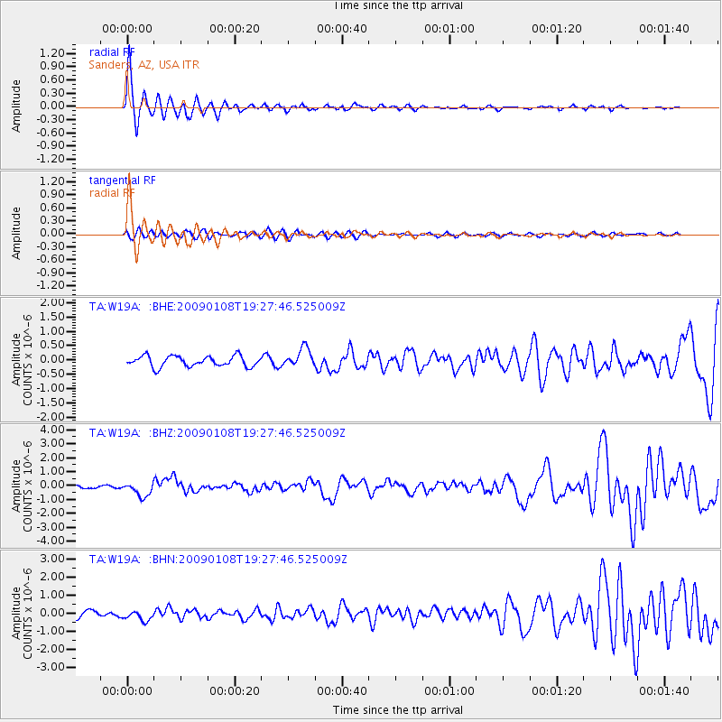
Signal To Noise
| Channel | StoN | STA | LTA |
| TA:W19A: :BHZ:20090108T19:27:46.525009Z | 2.9666412 | 5.016406E-7 | 1.690938E-7 |
| TA:W19A: :BHN:20090108T19:27:46.525009Z | 1.4660364 | 2.8082184E-7 | 1.9155175E-7 |
| TA:W19A: :BHE:20090108T19:27:46.525009Z | 1.7791408 | 3.3071743E-7 | 1.8588602E-7 |
| Arrivals |
| Ps | 3.3 SECOND |
| PpPs | 8.0 SECOND |
| PsPs/PpSs | 11 SECOND |


