You are here: Home > Network List > TS - TERRAscope (Southern California Seismic Network) Stations List
> Station BAR Barrett Dam, California, USA > Earthquake Result Viewer
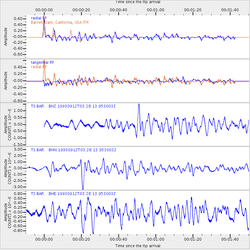
BAR Barrett Dam, California, USA - Earthquake Result Viewer
*The percent match for this event was below the threshold and hence no stack was calculated.
| Earthquake location: |
Near Coast Of Guatemala |
| Earthquake latitude/longitude: |
13.8/-90.5 |
| Earthquake time(UTC): |
1993/09/12 (255) 03:22:38 GMT |
| Earthquake Depth: |
69 km |
| Earthquake Magnitude: |
5.6 MB |
| Earthquake Catalog/Contributor: |
WHDF/NEIC |
|
| Network: |
TS TERRAscope (Southern California Seismic Network) |
| Station: |
BAR Barrett Dam, California, USA |
| Lat/Lon: |
32.68 N/116.67 W |
| Elevation: |
548 m |
|
| Distance: |
30.4 deg |
| Az: |
312.605 deg |
| Baz: |
122.022 deg |
| Ray Param: |
$rayparam |
*The percent match for this event was below the threshold and hence was not used in the summary stack. |
|
| Radial Match: |
69.740944 % |
| Radial Bump: |
377 |
| Transverse Match: |
65.65706 % |
| Transverse Bump: |
400 |
| SOD ConfigId: |
4480 |
| Insert Time: |
2010-02-26 14:00:42.663 +0000 |
| GWidth: |
2.5 |
| Max Bumps: |
400 |
| Tol: |
0.001 |
|
Signal To Noise
| Channel | StoN | STA | LTA |
| TS:BAR: :BHN:19930912T03:28:13.953003Z | 2.268207 | 6.195835E-7 | 2.7316003E-7 |
| TS:BAR: :BHE:19930912T03:28:13.953003Z | 1.6645061 | 2.5033265E-7 | 1.5039456E-7 |
| TS:BAR: :BHZ:19930912T03:28:13.953003Z | 1.0386835 | 1.6771709E-7 | 1.6147082E-7 |
| Arrivals |
| Ps | |
| PpPs | |
| PsPs/PpSs | |


