You are here: Home > Network List > TA - USArray Transportable Network (new EarthScope stations) Stations List
> Station C16K Lisburne Hills, AK, USA > Earthquake Result Viewer
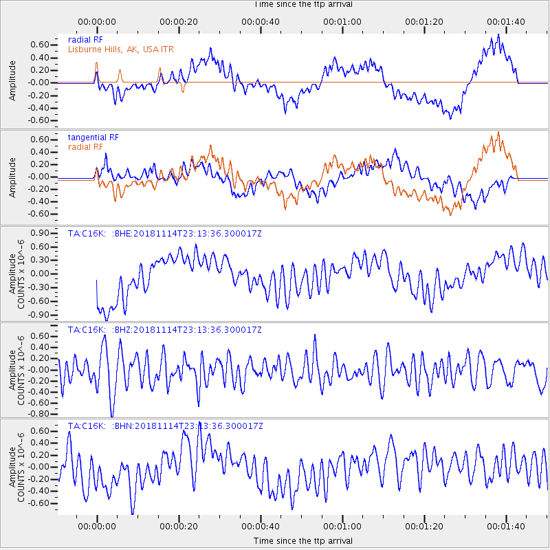
C16K Lisburne Hills, AK, USA - Earthquake Result Viewer
*The percent match for this event was below the threshold and hence no stack was calculated.
| Earthquake location: |
Sulawesi, Indonesia |
| Earthquake latitude/longitude: |
-2.9/119.4 |
| Earthquake time(UTC): |
2018/11/14 (318) 23:01:21 GMT |
| Earthquake Depth: |
13 km |
| Earthquake Magnitude: |
5.5 Mww |
| Earthquake Catalog/Contributor: |
NEIC PDE/us |
|
| Network: |
TA USArray Transportable Network (new EarthScope stations) |
| Station: |
C16K Lisburne Hills, AK, USA |
| Lat/Lon: |
68.27 N/165.34 W |
| Elevation: |
102 m |
|
| Distance: |
87.3 deg |
| Az: |
21.13 deg |
| Baz: |
255.241 deg |
| Ray Param: |
$rayparam |
*The percent match for this event was below the threshold and hence was not used in the summary stack. |
|
| Radial Match: |
51.94499 % |
| Radial Bump: |
400 |
| Transverse Match: |
46.062756 % |
| Transverse Bump: |
400 |
| SOD ConfigId: |
13570011 |
| Insert Time: |
2019-05-01 19:57:06.198 +0000 |
| GWidth: |
2.5 |
| Max Bumps: |
400 |
| Tol: |
0.001 |
|
Signal To Noise
| Channel | StoN | STA | LTA |
| TA:C16K: :BHZ:20181114T23:13:36.300017Z | 2.4379792 | 4.5377703E-7 | 1.8612835E-7 |
| TA:C16K: :BHN:20181114T23:13:36.300017Z | 1.2368733 | 3.2577228E-7 | 2.6338373E-7 |
| TA:C16K: :BHE:20181114T23:13:36.300017Z | 0.60748947 | 2.9066186E-7 | 4.784641E-7 |
| Arrivals |
| Ps | |
| PpPs | |
| PsPs/PpSs | |


