You are here: Home > Network List > 2H - Interim Broadband Monitoring of the Mount Erebus Volcano Stations List
> Station NAUS Mt Erebus site NAUS > Earthquake Result Viewer
NAUS Mt Erebus site NAUS - Earthquake Result Viewer
| Earthquake location: |
South Sandwich Islands Region |
| Earthquake latitude/longitude: |
-56.8/-25.4 |
| Earthquake time(UTC): |
2018/11/15 (319) 20:02:21 GMT |
| Earthquake Depth: |
10 km |
| Earthquake Magnitude: |
6.3 mww |
| Earthquake Catalog/Contributor: |
NEIC PDE/us |
|
| Network: |
2H Interim Broadband Monitoring of the Mount Erebus Volcano |
| Station: |
NAUS Mt Erebus site NAUS |
| Lat/Lon: |
77.52 S/167.15 E |
| Elevation: |
3590 m |
|
| Distance: |
45.7 deg |
| Az: |
183.78 deg |
| Baz: |
170.394 deg |
| Ray Param: |
0.07108522 |
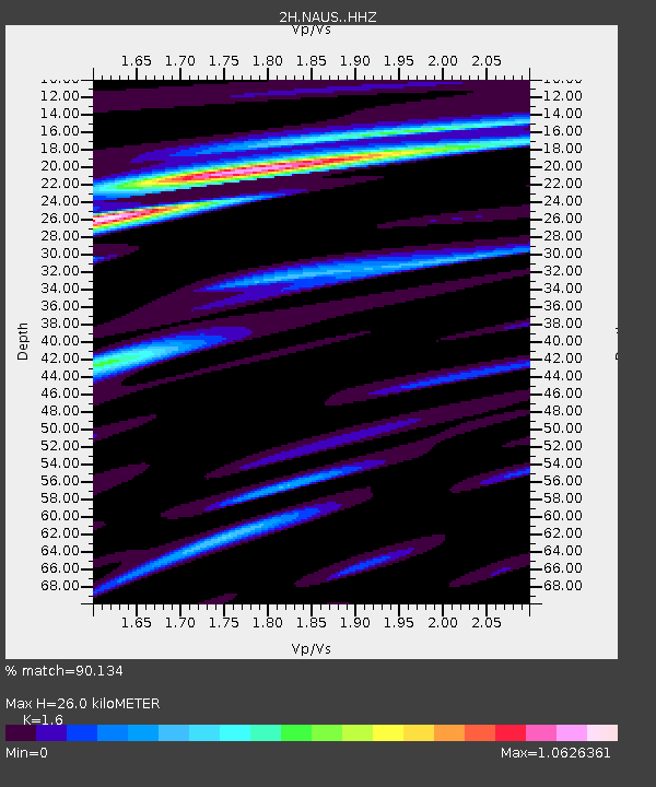
| Estimated Moho Depth: |
26.0 km |
| Estimated Crust Vp/Vs: |
1.60 |
| Assumed Crust Vp: |
6.183 km/s |
| Estimated Crust Vs: |
3.864 km/s |
| Estimated Crust Poisson's Ratio: |
0.18 |
|
| Radial Match: |
90.134 % |
| Radial Bump: |
400 |
| Transverse Match: |
69.79145 % |
| Transverse Bump: |
400 |
| SOD ConfigId: |
13570011 |
| Insert Time: |
2019-05-01 20:01:22.274 +0000 |
| GWidth: |
2.5 |
| Max Bumps: |
400 |
| Tol: |
0.001 |
|

Signal To Noise
| Channel | StoN | STA | LTA |
| 2H:NAUS: :HHZ:20181115T20:10:12.995004Z | 7.7097697 | 1.302304E-6 | 1.6891607E-7 |
| 2H:NAUS: :HH1:20181115T20:10:12.995004Z | 3.605355 | 7.9094303E-7 | 2.1938008E-7 |
| 2H:NAUS: :HH2:20181115T20:10:12.995004Z | 1.5955766 | 3.5421533E-7 | 2.2199833E-7 |
| Arrivals |
| Ps | 2.7 SECOND |
| PpPs | 10 SECOND |
| PsPs/PpSs | 13 SECOND |


