You are here: Home > Network List > C1 - Red Sismologica Nacional Stations List
> Station BO02 Daracena > Earthquake Result Viewer
BO02 Daracena - Earthquake Result Viewer
| Earthquake location: |
South Sandwich Islands Region |
| Earthquake latitude/longitude: |
-56.8/-25.4 |
| Earthquake time(UTC): |
2018/11/15 (319) 20:02:21 GMT |
| Earthquake Depth: |
10 km |
| Earthquake Magnitude: |
6.3 mww |
| Earthquake Catalog/Contributor: |
NEIC PDE/us |
|
| Network: |
C1 Red Sismologica Nacional |
| Station: |
BO02 Daracena |
| Lat/Lon: |
34.79 S/70.78 W |
| Elevation: |
886 m |
|
| Distance: |
37.6 deg |
| Az: |
286.162 deg |
| Baz: |
140.029 deg |
| Ray Param: |
0.076050535 |
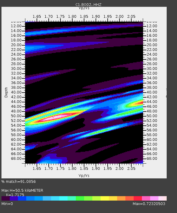
| Estimated Moho Depth: |
50.5 km |
| Estimated Crust Vp/Vs: |
1.72 |
| Assumed Crust Vp: |
6.481 km/s |
| Estimated Crust Vs: |
3.773 km/s |
| Estimated Crust Poisson's Ratio: |
0.24 |
|
| Radial Match: |
91.0856 % |
| Radial Bump: |
276 |
| Transverse Match: |
74.68626 % |
| Transverse Bump: |
400 |
| SOD ConfigId: |
13570011 |
| Insert Time: |
2019-05-01 20:01:57.434 +0000 |
| GWidth: |
2.5 |
| Max Bumps: |
400 |
| Tol: |
0.001 |
|

Signal To Noise
| Channel | StoN | STA | LTA |
| C1:BO02: :HHZ:20181115T20:09:05.087991Z | 3.572124 | 8.434437E-7 | 2.3611824E-7 |
| C1:BO02: :HHN:20181115T20:09:05.087991Z | 2.2890623 | 3.8591585E-7 | 1.6859123E-7 |
| C1:BO02: :HHE:20181115T20:09:05.087991Z | 1.7551705 | 4.4709088E-7 | 2.547279E-7 |
| Arrivals |
| Ps | 6.0 SECOND |
| PpPs | 20 SECOND |
| PsPs/PpSs | 26 SECOND |


