You are here: Home > Network List > C1 - Red Sismologica Nacional Stations List
> Station BO01 Tunca > Earthquake Result Viewer
BO01 Tunca - Earthquake Result Viewer
| Earthquake location: |
South Sandwich Islands Region |
| Earthquake latitude/longitude: |
-56.8/-25.4 |
| Earthquake time(UTC): |
2018/11/15 (319) 20:02:21 GMT |
| Earthquake Depth: |
10 km |
| Earthquake Magnitude: |
6.3 mww |
| Earthquake Catalog/Contributor: |
NEIC PDE/us |
|
| Network: |
C1 Red Sismologica Nacional |
| Station: |
BO01 Tunca |
| Lat/Lon: |
34.39 S/71.08 W |
| Elevation: |
262 m |
|
| Distance: |
38.1 deg |
| Az: |
286.267 deg |
| Baz: |
140.283 deg |
| Ray Param: |
0.07577908 |
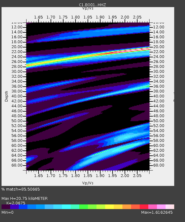
| Estimated Moho Depth: |
20.75 km |
| Estimated Crust Vp/Vs: |
2.07 |
| Assumed Crust Vp: |
6.481 km/s |
| Estimated Crust Vs: |
3.135 km/s |
| Estimated Crust Poisson's Ratio: |
0.35 |
|
| Radial Match: |
85.50665 % |
| Radial Bump: |
337 |
| Transverse Match: |
61.704002 % |
| Transverse Bump: |
400 |
| SOD ConfigId: |
13570011 |
| Insert Time: |
2019-05-01 20:01:58.406 +0000 |
| GWidth: |
2.5 |
| Max Bumps: |
400 |
| Tol: |
0.001 |
|

Signal To Noise
| Channel | StoN | STA | LTA |
| C1:BO01: :HHZ:20181115T20:09:09.027993Z | 6.210334 | 1.2444741E-6 | 2.0038763E-7 |
| C1:BO01: :HHN:20181115T20:09:09.027993Z | 2.9237113 | 6.83207E-7 | 2.3367801E-7 |
| C1:BO01: :HHE:20181115T20:09:09.027993Z | 3.5686464 | 6.7681145E-7 | 1.8965494E-7 |
| Arrivals |
| Ps | 3.6 SECOND |
| PpPs | 9.2 SECOND |
| PsPs/PpSs | 13 SECOND |


