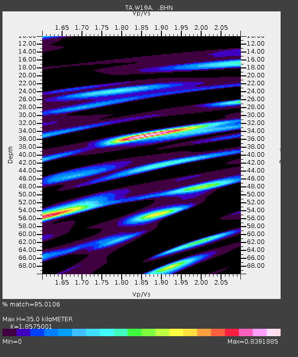
W19A Sanders, AZ, USA - Earthquake Result Viewer
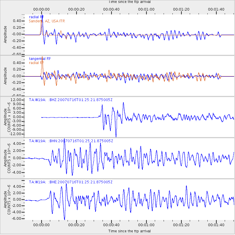
Earthquake location: Near West Coast Of Honshu, Japan
Earthquake latitude/longitude: 37.5/138.4
Earthquake time(UTC): 2007/07/16 (197) 01:13:22 GMT
Earthquake Depth: 12 km
Earthquake Magnitude: 6.5 MB, 6.4 MS, 6.6 MW, 6.5 MW
Earthquake Catalog/Contributor: WHDF/NEIC
Network: TA USArray Transportable Network (new EarthScope stations)
Station: W19A Sanders, AZ, USA
Lat/Lon: 35.11 N/109.39 W
Elevation: 1785 m
Distance: 84.2 deg
Az: 49.746 deg
Baz: 312.267 deg
Ray Param: 0.045664128
Estimated Moho Depth: 35.0 km
Estimated Crust Vp/Vs: 1.86
Assumed Crust Vp: 6.496 km/s
Estimated Crust Vs: 3.497 km/s
Estimated Crust Poisson's Ratio: 0.30
Radial Match: 95.0106 %
Radial Bump: 386
Transverse Match: 90.485405 %
Transverse Bump: 400
SOD ConfigId: 2564
Insert Time: 2010-03-06 18:01:32.194 +0000
GWidth: 2.5
Max Bumps: 400
Tol: 0.001

Signal To Noise

ChannelStoNSTALTA
TA:W19A: :BHN:20070716T01:25:21.875005Z4.48357774.0008717E-78.923391E-8
TA:W19A: :BHE:20070716T01:25:21.875005Z5.38658245.219272E-79.689394E-8
TA:W19A: :BHZ:20070716T01:25:21.875005Z42.0870362.5709708E-66.1087E-8
Arrivals
Ps4.7 SECOND
PpPs15 SECOND
PsPs/PpSs20 SECOND