You are here: Home > Network List > TA - USArray Transportable Network (new EarthScope stations) Stations List
> Station W19A Sanders, AZ, USA > Earthquake Result Viewer
W19A Sanders, AZ, USA - Earthquake Result Viewer
| Earthquake location: |
Near Coast Of Central Chile |
| Earthquake latitude/longitude: |
-32.0/-71.3 |
| Earthquake time(UTC): |
2007/06/28 (179) 19:25:21 GMT |
| Earthquake Depth: |
69 km |
| Earthquake Magnitude: |
5.5 MB, 5.7 MW, 5.6 MW |
| Earthquake Catalog/Contributor: |
WHDF/NEIC |
|
| Network: |
TA USArray Transportable Network (new EarthScope stations) |
| Station: |
W19A Sanders, AZ, USA |
| Lat/Lon: |
35.11 N/109.39 W |
| Elevation: |
1785 m |
|
| Distance: |
75.7 deg |
| Az: |
328.575 deg |
| Baz: |
147.296 deg |
| Ray Param: |
0.051326875 |
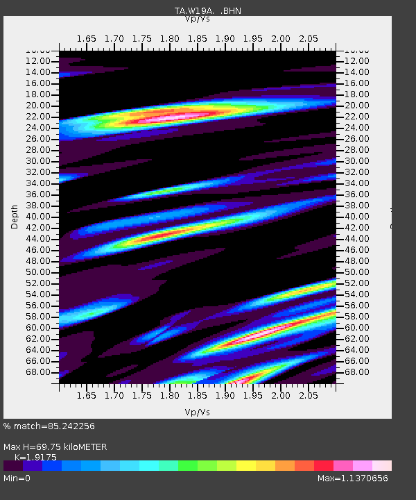
| Estimated Moho Depth: |
69.75 km |
| Estimated Crust Vp/Vs: |
1.92 |
| Assumed Crust Vp: |
6.496 km/s |
| Estimated Crust Vs: |
3.388 km/s |
| Estimated Crust Poisson's Ratio: |
0.31 |
|
| Radial Match: |
85.242256 % |
| Radial Bump: |
400 |
| Transverse Match: |
66.56835 % |
| Transverse Bump: |
400 |
| SOD ConfigId: |
2564 |
| Insert Time: |
2010-03-06 18:01:43.060 +0000 |
| GWidth: |
2.5 |
| Max Bumps: |
400 |
| Tol: |
0.001 |
|
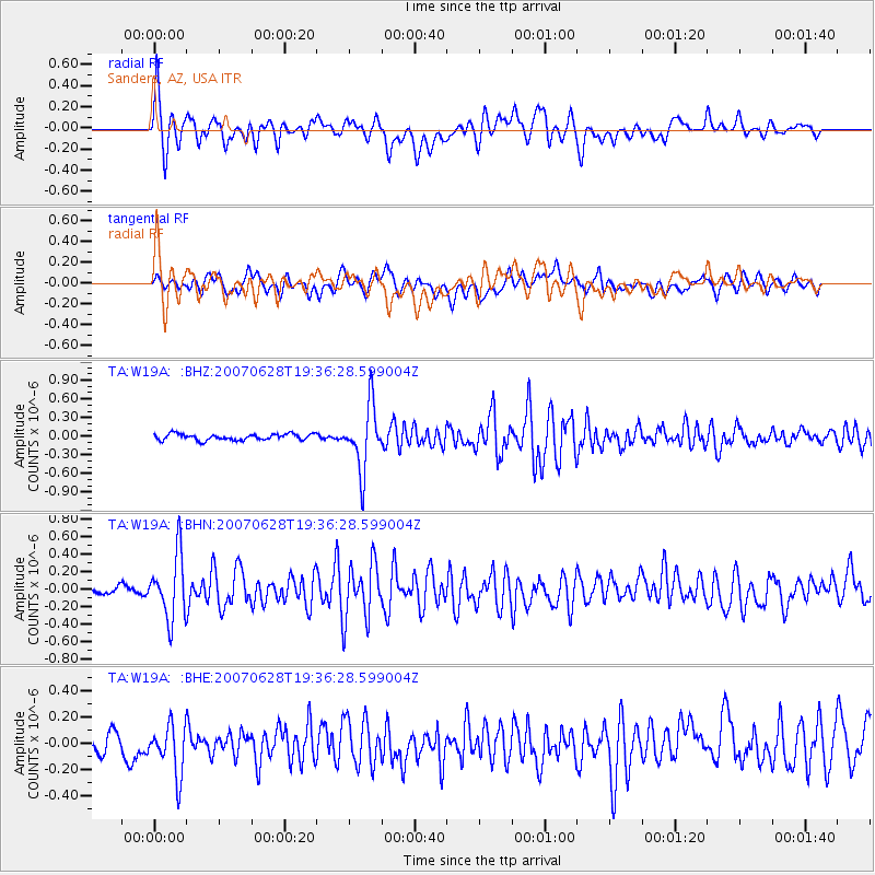
Signal To Noise
| Channel | StoN | STA | LTA |
| TA:W19A: :BHN:20070628T19:36:28.599004Z | 3.918214 | 3.6601094E-7 | 9.3412694E-8 |
| TA:W19A: :BHE:20070628T19:36:28.599004Z | 2.6242342 | 1.946608E-7 | 7.417813E-8 |
| TA:W19A: :BHZ:20070628T19:36:28.599004Z | 10.328765 | 5.1311014E-7 | 4.9677777E-8 |
| Arrivals |
| Ps | 10 SECOND |
| PpPs | 30 SECOND |
| PsPs/PpSs | 41 SECOND |


