You are here: Home > Network List > TA - USArray Transportable Network (new EarthScope stations) Stations List
> Station W19A Sanders, AZ, USA > Earthquake Result Viewer
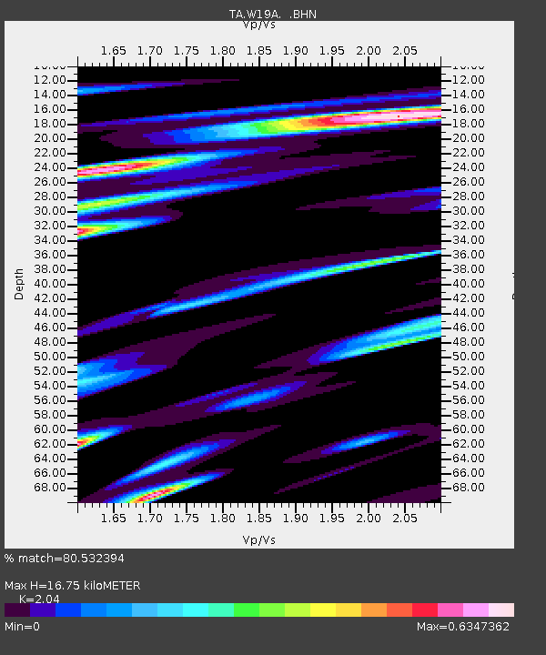
W19A Sanders, AZ, USA - Earthquake Result Viewer
| Earthquake location: |
Hokkaido, Japan Region |
| Earthquake latitude/longitude: |
41.6/142.0 |
| Earthquake time(UTC): |
2007/05/18 (138) 15:59:58 GMT |
| Earthquake Depth: |
58 km |
| Earthquake Magnitude: |
5.5 MB, 5.5 MW, 5.4 MW |
| Earthquake Catalog/Contributor: |
WHDF/NEIC |
|
| Network: |
TA USArray Transportable Network (new EarthScope stations) |
| Station: |
W19A Sanders, AZ, USA |
| Lat/Lon: |
35.11 N/109.39 W |
| Elevation: |
1785 m |
|
| Distance: |
79.5 deg |
| Az: |
52.202 deg |
| Baz: |
313.706 deg |
| Ray Param: |
0.04881136 |
| Estimated Moho Depth: |
16.75 km |
| Estimated Crust Vp/Vs: |
2.04 |
| Assumed Crust Vp: |
6.496 km/s |
| Estimated Crust Vs: |
3.184 km/s |
| Estimated Crust Poisson's Ratio: |
0.34 |
|
| Radial Match: |
80.532394 % |
| Radial Bump: |
400 |
| Transverse Match: |
62.840313 % |
| Transverse Bump: |
400 |
| SOD ConfigId: |
2564 |
| Insert Time: |
2010-03-06 18:01:47.712 +0000 |
| GWidth: |
2.5 |
| Max Bumps: |
400 |
| Tol: |
0.001 |
|

Signal To Noise
| Channel | StoN | STA | LTA |
| TA:W19A: :BHN:20070518T16:11:27.850007Z | 0.8330401 | 9.573376E-8 | 1.1492095E-7 |
| TA:W19A: :BHE:20070518T16:11:27.850007Z | 1.3097714 | 1.0429831E-7 | 7.963092E-8 |
| TA:W19A: :BHZ:20070518T16:11:27.850007Z | 3.5837207 | 1.8438202E-7 | 5.1449888E-8 |
| Arrivals |
| Ps | 2.8 SECOND |
| PpPs | 7.6 SECOND |
| PsPs/PpSs | 10 SECOND |


