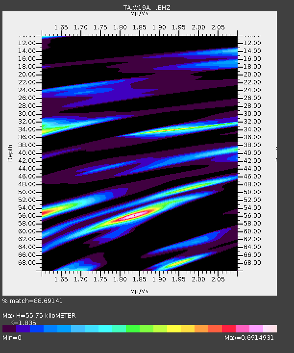
W19A Sanders, AZ, USA - Earthquake Result Viewer
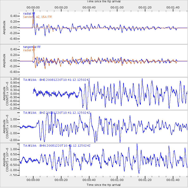
Earthquake location: Off East Coast Of Honshu, Japan
Earthquake latitude/longitude: 36.5/142.4
Earthquake time(UTC): 2008/12/20 (355) 10:29:23 GMT
Earthquake Depth: 19 km
Earthquake Magnitude: 6.0 MB, 6.3 MS, 6.3 MW, 6.3 MW
Earthquake Catalog/Contributor: WHDF/NEIC
Network: TA USArray Transportable Network (new EarthScope stations)
Station: W19A Sanders, AZ, USA
Lat/Lon: 35.11 N/109.39 W
Elevation: 1785 m
Distance: 82.3 deg
Az: 51.805 deg
Baz: 309.466 deg
Ray Param: 0.046941936
Estimated Moho Depth: 55.75 km
Estimated Crust Vp/Vs: 1.84
Assumed Crust Vp: 6.496 km/s
Estimated Crust Vs: 3.54 km/s
Estimated Crust Poisson's Ratio: 0.29
Radial Match: 88.69141 %
Radial Bump: 400
Transverse Match: 70.2027 %
Transverse Bump: 400
SOD ConfigId: 2658
Insert Time: 2010-03-06 18:01:52.510 +0000
GWidth: 2.5
Max Bumps: 400
Tol: 0.001

Signal To Noise

ChannelStoNSTALTA
TA:W19A: :BHZ:20081220T10:41:12.125024Z3.90595034.437343E-71.136047E-7
TA:W19A: :BHN:20081220T10:41:12.125024Z0.98731661.8429186E-71.8665935E-7
TA:W19A: :BHE:20081220T10:41:12.125024Z1.78670612.396463E-71.3412745E-7
Arrivals
Ps7.4 SECOND
PpPs24 SECOND
PsPs/PpSs31 SECOND