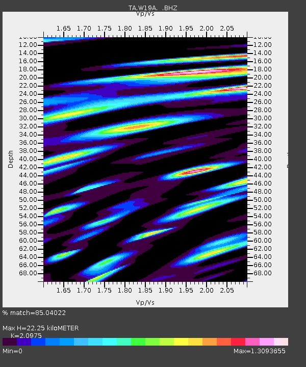
W19A Sanders, AZ, USA - Earthquake Result Viewer
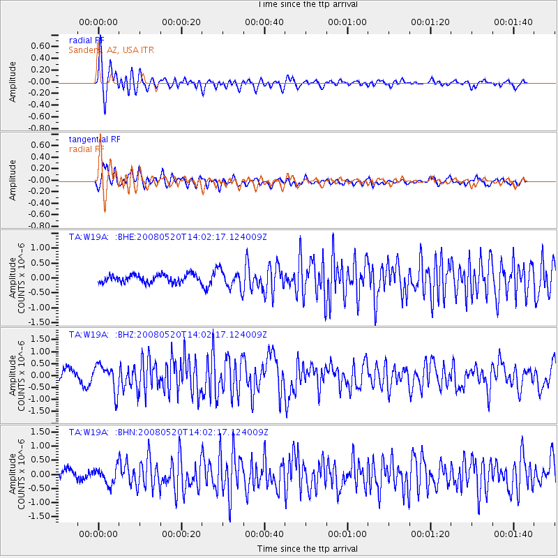
Earthquake location: Rat Islands, Aleutian Islands
Earthquake latitude/longitude: 51.2/178.8
Earthquake time(UTC): 2008/05/20 (141) 13:53:35 GMT
Earthquake Depth: 27 km
Earthquake Magnitude: 5.8 MB, 6.0 MS, 6.3 MW, 6.3 MW
Earthquake Catalog/Contributor: WHDF/NEIC
Network: TA USArray Transportable Network (new EarthScope stations)
Station: W19A Sanders, AZ, USA
Lat/Lon: 35.11 N/109.39 W
Elevation: 1785 m
Distance: 52.7 deg
Az: 78.241 deg
Baz: 311.243 deg
Ray Param: 0.06653047
Estimated Moho Depth: 22.25 km
Estimated Crust Vp/Vs: 2.10
Assumed Crust Vp: 6.496 km/s
Estimated Crust Vs: 3.097 km/s
Estimated Crust Poisson's Ratio: 0.35
Radial Match: 85.04022 %
Radial Bump: 400
Transverse Match: 81.5789 %
Transverse Bump: 400
SOD ConfigId: 2504
Insert Time: 2010-03-06 18:02:06.082 +0000
GWidth: 2.5
Max Bumps: 400
Tol: 0.001

Signal To Noise

ChannelStoNSTALTA
TA:W19A: :BHZ:20080520T14:02:17.124009Z1.93806375.7275867E-72.9553138E-7
TA:W19A: :BHN:20080520T14:02:17.124009Z1.28543762.9841905E-72.3215367E-7
TA:W19A: :BHE:20080520T14:02:17.124009Z2.41081293.133973E-71.2999652E-7
Arrivals
Ps3.9 SECOND
PpPs10 SECOND
PsPs/PpSs14 SECOND