You are here: Home > Network List > TA - USArray Transportable Network (new EarthScope stations) Stations List
> Station W19A Sanders, AZ, USA > Earthquake Result Viewer
W19A Sanders, AZ, USA - Earthquake Result Viewer

| Earthquake location: |
Central Mid-Atlantic Ridge |
| Earthquake latitude/longitude: |
7.3/-34.9 |
| Earthquake time(UTC): |
2008/05/23 (144) 19:35:34 GMT |
| Earthquake Depth: |
9.0 km |
| Earthquake Magnitude: |
6.0 MB, 6.4 MS, 6.5 MW, 6.5 MW |
| Earthquake Catalog/Contributor: |
WHDF/NEIC |
|
| Network: |
TA USArray Transportable Network (new EarthScope stations) |
| Station: |
W19A Sanders, AZ, USA |
| Lat/Lon: |
35.11 N/109.39 W |
| Elevation: |
1785 m |
|
| Distance: |
73.2 deg |
| Az: |
304.368 deg |
| Baz: |
92.887 deg |
| Ray Param: |
0.05319521 |
| Estimated Moho Depth: |
21.0 km |
| Estimated Crust Vp/Vs: |
1.96 |
| Assumed Crust Vp: |
6.496 km/s |
| Estimated Crust Vs: |
3.314 km/s |
| Estimated Crust Poisson's Ratio: |
0.32 |
|
| Radial Match: |
88.64617 % |
| Radial Bump: |
386 |
| Transverse Match: |
84.05696 % |
| Transverse Bump: |
400 |
| SOD ConfigId: |
2504 |
| Insert Time: |
2010-03-06 18:02:07.538 +0000 |
| GWidth: |
2.5 |
| Max Bumps: |
400 |
| Tol: |
0.001 |
|
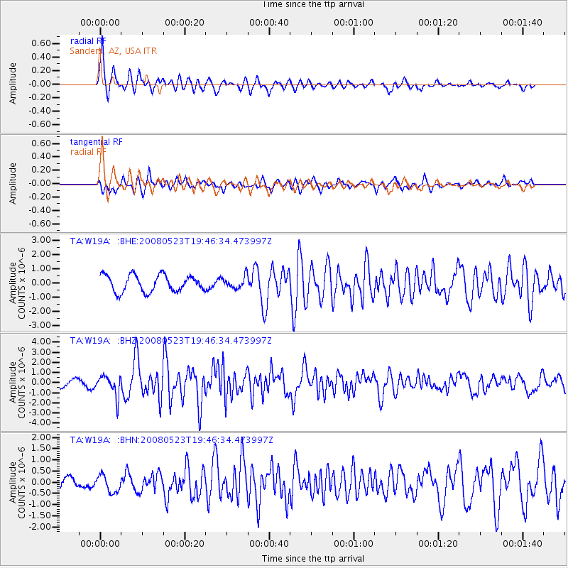
Signal To Noise
| Channel | StoN | STA | LTA |
| TA:W19A: :BHZ:20080523T19:46:34.473997Z | 1.853294 | 1.0369976E-6 | 5.595429E-7 |
| TA:W19A: :BHN:20080523T19:46:34.473997Z | 0.9813992 | 3.9023251E-7 | 3.9762872E-7 |
| TA:W19A: :BHE:20080523T19:46:34.473997Z | 0.73368996 | 4.219053E-7 | 5.7504576E-7 |
| Arrivals |
| Ps | 3.2 SECOND |
| PpPs | 9.3 SECOND |
| PsPs/PpSs | 12 SECOND |


