You are here: Home > Network List > TA - USArray Transportable Network (new EarthScope stations) Stations List
> Station W19A Sanders, AZ, USA > Earthquake Result Viewer
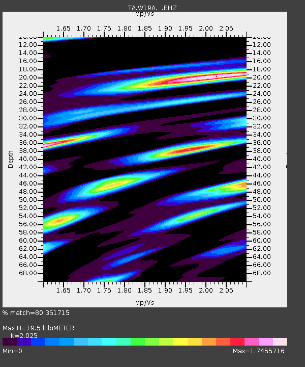
W19A Sanders, AZ, USA - Earthquake Result Viewer
| Earthquake location: |
Colombia |
| Earthquake latitude/longitude: |
4.3/-73.8 |
| Earthquake time(UTC): |
2008/05/24 (145) 19:20:42 GMT |
| Earthquake Depth: |
8.9 km |
| Earthquake Magnitude: |
5.6 MB, 5.6 MS, 5.9 MW, 5.9 MW |
| Earthquake Catalog/Contributor: |
WHDF/NEIC |
|
| Network: |
TA USArray Transportable Network (new EarthScope stations) |
| Station: |
W19A Sanders, AZ, USA |
| Lat/Lon: |
35.11 N/109.39 W |
| Elevation: |
1785 m |
|
| Distance: |
45.0 deg |
| Az: |
317.493 deg |
| Baz: |
124.73 deg |
| Ray Param: |
0.07159031 |
| Estimated Moho Depth: |
19.5 km |
| Estimated Crust Vp/Vs: |
2.03 |
| Assumed Crust Vp: |
6.496 km/s |
| Estimated Crust Vs: |
3.208 km/s |
| Estimated Crust Poisson's Ratio: |
0.34 |
|
| Radial Match: |
80.351715 % |
| Radial Bump: |
400 |
| Transverse Match: |
69.82925 % |
| Transverse Bump: |
400 |
| SOD ConfigId: |
2504 |
| Insert Time: |
2010-03-06 18:02:09.476 +0000 |
| GWidth: |
2.5 |
| Max Bumps: |
400 |
| Tol: |
0.001 |
|

Signal To Noise
| Channel | StoN | STA | LTA |
| TA:W19A: :BHZ:20080524T19:28:26.974009Z | 1.6763176 | 6.8285624E-7 | 4.0735492E-7 |
| TA:W19A: :BHN:20080524T19:28:26.974009Z | 1.4280863 | 3.7773492E-7 | 2.6450428E-7 |
| TA:W19A: :BHE:20080524T19:28:26.974009Z | 1.0553952 | 4.504411E-7 | 4.267985E-7 |
| Arrivals |
| Ps | 3.3 SECOND |
| PpPs | 8.6 SECOND |
| PsPs/PpSs | 12 SECOND |


