You are here: Home > Network List > AK - Alaska Regional Network Stations List
> Station GHO Gloryhole, AK, USA > Earthquake Result Viewer
GHO Gloryhole, AK, USA - Earthquake Result Viewer
| Earthquake location: |
Solomon Islands |
| Earthquake latitude/longitude: |
-10.5/163.1 |
| Earthquake time(UTC): |
2018/11/16 (320) 03:26:55 GMT |
| Earthquake Depth: |
11 km |
| Earthquake Magnitude: |
6.2 mww |
| Earthquake Catalog/Contributor: |
NEIC PDE/us |
|
| Network: |
AK Alaska Regional Network |
| Station: |
GHO Gloryhole, AK, USA |
| Lat/Lon: |
61.77 N/148.92 W |
| Elevation: |
1038 m |
|
| Distance: |
81.2 deg |
| Az: |
20.933 deg |
| Baz: |
227.644 deg |
| Ray Param: |
0.047773242 |
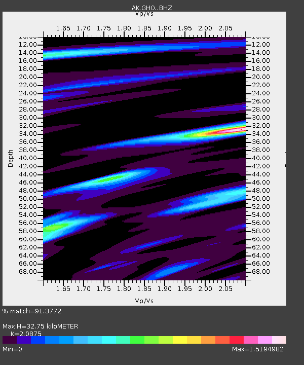
| Estimated Moho Depth: |
32.75 km |
| Estimated Crust Vp/Vs: |
2.09 |
| Assumed Crust Vp: |
6.566 km/s |
| Estimated Crust Vs: |
3.145 km/s |
| Estimated Crust Poisson's Ratio: |
0.35 |
|
| Radial Match: |
91.3772 % |
| Radial Bump: |
400 |
| Transverse Match: |
79.47897 % |
| Transverse Bump: |
400 |
| SOD ConfigId: |
13570011 |
| Insert Time: |
2019-05-01 20:11:31.798 +0000 |
| GWidth: |
2.5 |
| Max Bumps: |
400 |
| Tol: |
0.001 |
|

Signal To Noise
| Channel | StoN | STA | LTA |
| AK:GHO: :BHZ:20181116T03:38:39.908003Z | 10.390912 | 2.1425185E-6 | 2.0619157E-7 |
| AK:GHO: :BHN:20181116T03:38:39.908003Z | 3.1910787 | 7.743856E-7 | 2.4267206E-7 |
| AK:GHO: :BHE:20181116T03:38:39.908003Z | 1.4840407 | 3.4943452E-7 | 2.3546156E-7 |
| Arrivals |
| Ps | 5.6 SECOND |
| PpPs | 15 SECOND |
| PsPs/PpSs | 21 SECOND |


