You are here: Home > Network List > AV - Alaska Volcano Observatory Stations List
> Station SPCR Ckakachatna River, Mount Spurr, Alaska > Earthquake Result Viewer
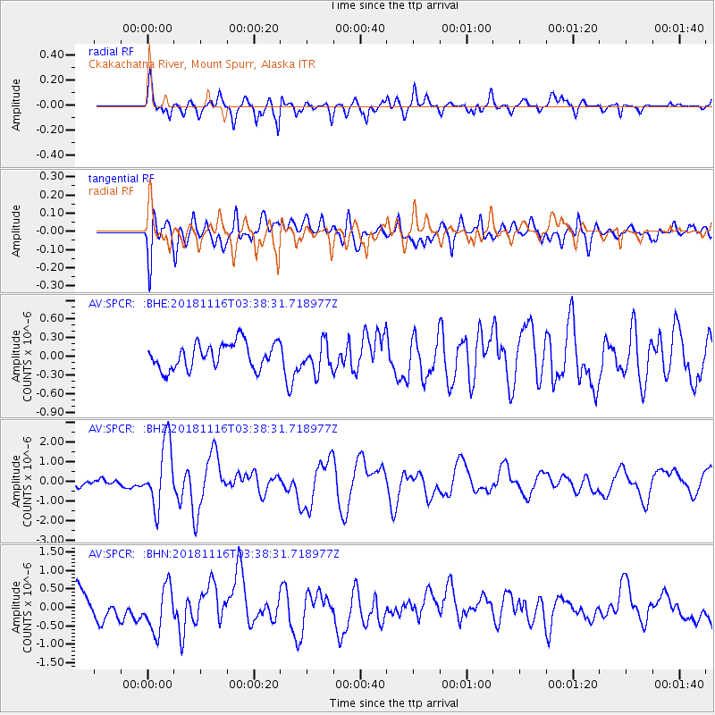
SPCR Ckakachatna River, Mount Spurr, Alaska - Earthquake Result Viewer
*The percent match for this event was below the threshold and hence no stack was calculated.
| Earthquake location: |
Solomon Islands |
| Earthquake latitude/longitude: |
-10.5/163.1 |
| Earthquake time(UTC): |
2018/11/16 (320) 03:26:55 GMT |
| Earthquake Depth: |
11 km |
| Earthquake Magnitude: |
6.2 mww |
| Earthquake Catalog/Contributor: |
NEIC PDE/us |
|
| Network: |
AV Alaska Volcano Observatory |
| Station: |
SPCR Ckakachatna River, Mount Spurr, Alaska |
| Lat/Lon: |
61.20 N/152.21 W |
| Elevation: |
984 m |
|
| Distance: |
79.6 deg |
| Az: |
20.245 deg |
| Baz: |
224.646 deg |
| Ray Param: |
$rayparam |
*The percent match for this event was below the threshold and hence was not used in the summary stack. |
|
| Radial Match: |
67.99995 % |
| Radial Bump: |
400 |
| Transverse Match: |
75.780205 % |
| Transverse Bump: |
400 |
| SOD ConfigId: |
13570011 |
| Insert Time: |
2019-05-01 20:13:16.148 +0000 |
| GWidth: |
2.5 |
| Max Bumps: |
400 |
| Tol: |
0.001 |
|
Signal To Noise
| Channel | StoN | STA | LTA |
| AV:SPCR: :BHZ:20181116T03:38:31.718977Z | 10.516945 | 1.6414479E-6 | 1.5607648E-7 |
| AV:SPCR: :BHN:20181116T03:38:31.718977Z | 1.7092526 | 6.1605715E-7 | 3.6042488E-7 |
| AV:SPCR: :BHE:20181116T03:38:31.718977Z | 1.1317225 | 2.3239049E-7 | 2.0534229E-7 |
| Arrivals |
| Ps | |
| PpPs | |
| PsPs/PpSs | |


