You are here: Home > Network List > TA - USArray Transportable Network (new EarthScope stations) Stations List
> Station W19A Sanders, AZ, USA > Earthquake Result Viewer
W19A Sanders, AZ, USA - Earthquake Result Viewer
*The percent match for this event was below the threshold and hence no stack was calculated.
| Earthquake location: |
Northern Algeria |
| Earthquake latitude/longitude: |
35.9/-0.7 |
| Earthquake time(UTC): |
2008/06/06 (158) 20:02:56 GMT |
| Earthquake Depth: |
4.0 km |
| Earthquake Magnitude: |
5.5 MB, 5.3 MS, 5.5 MW, 5.5 MW |
| Earthquake Catalog/Contributor: |
WHDF/NEIC |
|
| Network: |
TA USArray Transportable Network (new EarthScope stations) |
| Station: |
W19A Sanders, AZ, USA |
| Lat/Lon: |
35.11 N/109.39 W |
| Elevation: |
1785 m |
|
| Distance: |
83.1 deg |
| Az: |
308.546 deg |
| Baz: |
50.778 deg |
| Ray Param: |
$rayparam |
*The percent match for this event was below the threshold and hence was not used in the summary stack. |
|
| Radial Match: |
58.738625 % |
| Radial Bump: |
400 |
| Transverse Match: |
64.66997 % |
| Transverse Bump: |
400 |
| SOD ConfigId: |
2504 |
| Insert Time: |
2010-03-06 18:03:47.171 +0000 |
| GWidth: |
2.5 |
| Max Bumps: |
400 |
| Tol: |
0.001 |
|
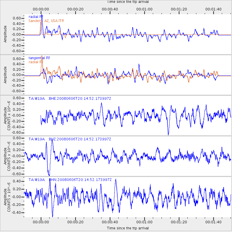
Signal To Noise
| Channel | StoN | STA | LTA |
| TA:W19A: :BHZ:20080606T20:14:52.173997Z | 2.8799434 | 2.7799877E-7 | 9.652925E-8 |
| TA:W19A: :BHN:20080606T20:14:52.173997Z | 0.9533195 | 1.385348E-7 | 1.4531834E-7 |
| TA:W19A: :BHE:20080606T20:14:52.173997Z | 1.342421 | 1.6255088E-7 | 1.2108784E-7 |
| Arrivals |
| Ps | |
| PpPs | |
| PsPs/PpSs | |


