You are here: Home > Network List > JP - Japan Meteorological Agency Seismic Network Stations List
> Station JMN Kochi Monobe > Earthquake Result Viewer
JMN Kochi Monobe - Earthquake Result Viewer
| Earthquake location: |
Solomon Islands |
| Earthquake latitude/longitude: |
-10.5/163.1 |
| Earthquake time(UTC): |
2018/11/16 (320) 03:26:55 GMT |
| Earthquake Depth: |
11 km |
| Earthquake Magnitude: |
6.2 mww |
| Earthquake Catalog/Contributor: |
NEIC PDE/us |
|
| Network: |
JP Japan Meteorological Agency Seismic Network |
| Station: |
JMN Kochi Monobe |
| Lat/Lon: |
33.73 N/133.88 E |
| Elevation: |
550 m |
|
| Distance: |
52.1 deg |
| Az: |
328.918 deg |
| Baz: |
142.468 deg |
| Ray Param: |
0.0669948 |
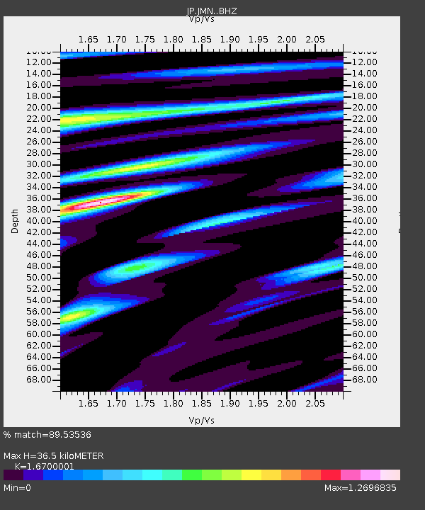
| Estimated Moho Depth: |
36.5 km |
| Estimated Crust Vp/Vs: |
1.67 |
| Assumed Crust Vp: |
6.468 km/s |
| Estimated Crust Vs: |
3.873 km/s |
| Estimated Crust Poisson's Ratio: |
0.22 |
|
| Radial Match: |
89.53536 % |
| Radial Bump: |
380 |
| Transverse Match: |
76.9557 % |
| Transverse Bump: |
400 |
| SOD ConfigId: |
13570011 |
| Insert Time: |
2019-05-01 20:16:08.691 +0000 |
| GWidth: |
2.5 |
| Max Bumps: |
400 |
| Tol: |
0.001 |
|

Signal To Noise
| Channel | StoN | STA | LTA |
| JP:JMN: :BHZ:20181116T03:35:34.799971Z | 10.187293 | 1.8222947E-6 | 1.7887919E-7 |
| JP:JMN: :BHN:20181116T03:35:34.799971Z | 3.1910923 | 7.6594495E-7 | 2.4002597E-7 |
| JP:JMN: :BHE:20181116T03:35:34.799971Z | 2.633116 | 5.5001067E-7 | 2.0888204E-7 |
| Arrivals |
| Ps | 4.0 SECOND |
| PpPs | 14 SECOND |
| PsPs/PpSs | 18 SECOND |


