You are here: Home > Network List > TA - USArray Transportable Network (new EarthScope stations) Stations List
> Station Q14A Sevier Lake (BLM), Delta, UT, USA > Earthquake Result Viewer
Q14A Sevier Lake (BLM), Delta, UT, USA - Earthquake Result Viewer
| Earthquake location: |
Off East Coast Of Honshu, Japan |
| Earthquake latitude/longitude: |
37.6/142.2 |
| Earthquake time(UTC): |
2008/07/19 (201) 02:39:28 GMT |
| Earthquake Depth: |
22 km |
| Earthquake Magnitude: |
6.2 MB, 7.0 MS, 7.0 MW, 6.9 MW |
| Earthquake Catalog/Contributor: |
WHDF/NEIC |
|
| Network: |
TA USArray Transportable Network (new EarthScope stations) |
| Station: |
Q14A Sevier Lake (BLM), Delta, UT, USA |
| Lat/Lon: |
38.99 N/113.28 W |
| Elevation: |
1464 m |
|
| Distance: |
77.0 deg |
| Az: |
50.747 deg |
| Baz: |
307.843 deg |
| Ray Param: |
0.050600532 |
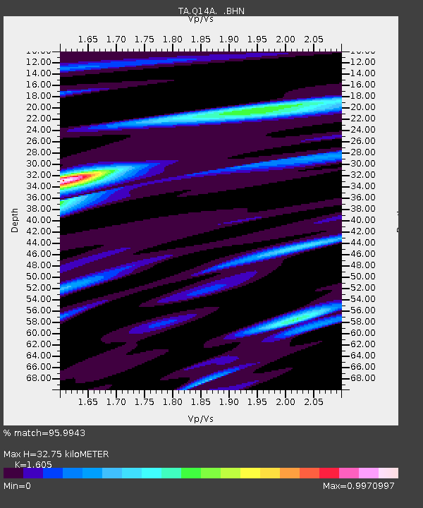
| Estimated Moho Depth: |
32.75 km |
| Estimated Crust Vp/Vs: |
1.61 |
| Assumed Crust Vp: |
6.276 km/s |
| Estimated Crust Vs: |
3.91 km/s |
| Estimated Crust Poisson's Ratio: |
0.18 |
|
| Radial Match: |
95.9943 % |
| Radial Bump: |
400 |
| Transverse Match: |
81.88124 % |
| Transverse Bump: |
400 |
| SOD ConfigId: |
2504 |
| Insert Time: |
2010-03-06 18:03:50.899 +0000 |
| GWidth: |
2.5 |
| Max Bumps: |
400 |
| Tol: |
0.001 |
|
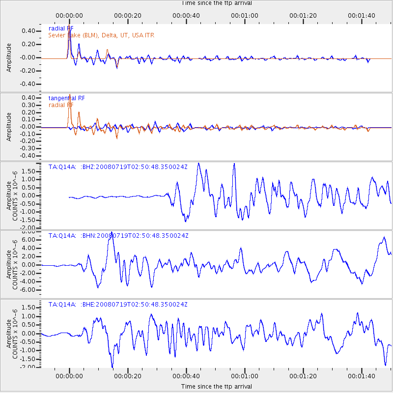
Signal To Noise
| Channel | StoN | STA | LTA |
| TA:Q14A: :BHN:20080719T02:50:48.350024Z | 3.040962 | 3.4638776E-7 | 1.139073E-7 |
| TA:Q14A: :BHE:20080719T02:50:48.350024Z | 1.066245 | 9.248262E-8 | 8.6736755E-8 |
| TA:Q14A: :BHZ:20080719T02:50:48.350024Z | 2.924729 | 1.2595032E-7 | 4.3063928E-8 |
| Arrivals |
| Ps | 3.3 SECOND |
| PpPs | 13 SECOND |
| PsPs/PpSs | 16 SECOND |


