You are here: Home > Network List > CU - Caribbean Network (USGS) Stations List
> Station BBGH Gun Hill, Barbados > Earthquake Result Viewer
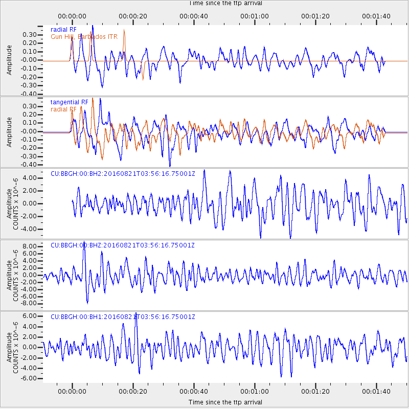
BBGH Gun Hill, Barbados - Earthquake Result Viewer
*The percent match for this event was below the threshold and hence no stack was calculated.
| Earthquake location: |
South Georgia Island Region |
| Earthquake latitude/longitude: |
-55.3/-31.8 |
| Earthquake time(UTC): |
2016/08/21 (234) 03:45:23 GMT |
| Earthquake Depth: |
10 km |
| Earthquake Magnitude: |
6.4 MWP |
| Earthquake Catalog/Contributor: |
NEIC PDE/NEIC COMCAT |
|
| Network: |
CU Caribbean Network (USGS) |
| Station: |
BBGH Gun Hill, Barbados |
| Lat/Lon: |
13.14 N/59.56 W |
| Elevation: |
180 m |
|
| Distance: |
72.1 deg |
| Az: |
331.474 deg |
| Baz: |
163.709 deg |
| Ray Param: |
$rayparam |
*The percent match for this event was below the threshold and hence was not used in the summary stack. |
|
| Radial Match: |
62.384335 % |
| Radial Bump: |
400 |
| Transverse Match: |
73.54201 % |
| Transverse Bump: |
400 |
| SOD ConfigId: |
1634031 |
| Insert Time: |
2016-09-04 03:46:07.018 +0000 |
| GWidth: |
2.5 |
| Max Bumps: |
400 |
| Tol: |
0.001 |
|
Signal To Noise
| Channel | StoN | STA | LTA |
| CU:BBGH:00:BHZ:20160821T03:56:16.75001Z | 3.1186445 | 3.4148254E-6 | 1.094971E-6 |
| CU:BBGH:00:BH1:20160821T03:56:16.75001Z | 0.86618835 | 1.0238753E-6 | 1.1820468E-6 |
| CU:BBGH:00:BH2:20160821T03:56:16.75001Z | 0.93478817 | 8.9482717E-7 | 9.572512E-7 |
| Arrivals |
| Ps | |
| PpPs | |
| PsPs/PpSs | |


