You are here: Home > Network List > TA - USArray Transportable Network (new EarthScope stations) Stations List
> Station Q14A Sevier Lake (BLM), Delta, UT, USA > Earthquake Result Viewer
Q14A Sevier Lake (BLM), Delta, UT, USA - Earthquake Result Viewer

| Earthquake location: |
Bonin Islands, Japan Region |
| Earthquake latitude/longitude: |
26.8/142.4 |
| Earthquake time(UTC): |
2008/02/27 (058) 06:54:20 GMT |
| Earthquake Depth: |
15 km |
| Earthquake Magnitude: |
5.8 MB, 6.1 MS, 6.2 MW, 6.2 MW |
| Earthquake Catalog/Contributor: |
WHDF/NEIC |
|
| Network: |
TA USArray Transportable Network (new EarthScope stations) |
| Station: |
Q14A Sevier Lake (BLM), Delta, UT, USA |
| Lat/Lon: |
38.99 N/113.28 W |
| Elevation: |
1464 m |
|
| Distance: |
83.7 deg |
| Az: |
49.446 deg |
| Baz: |
299.394 deg |
| Ray Param: |
0.045975506 |
| Estimated Moho Depth: |
31.75 km |
| Estimated Crust Vp/Vs: |
1.69 |
| Assumed Crust Vp: |
6.276 km/s |
| Estimated Crust Vs: |
3.708 km/s |
| Estimated Crust Poisson's Ratio: |
0.23 |
|
| Radial Match: |
80.39357 % |
| Radial Bump: |
372 |
| Transverse Match: |
69.5004 % |
| Transverse Bump: |
351 |
| SOD ConfigId: |
2564 |
| Insert Time: |
2010-03-06 18:04:26.110 +0000 |
| GWidth: |
2.5 |
| Max Bumps: |
400 |
| Tol: |
0.001 |
|
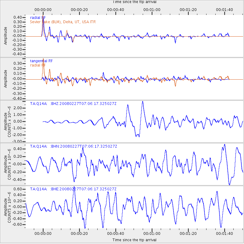
Signal To Noise
| Channel | StoN | STA | LTA |
| TA:Q14A: :BHN:20080227T07:06:17.325027Z | 1.0275289 | 1.1236649E-7 | 1.0935604E-7 |
| TA:Q14A: :BHE:20080227T07:06:17.325027Z | 0.43890867 | 1.0177977E-7 | 2.3189281E-7 |
| TA:Q14A: :BHZ:20080227T07:06:17.325027Z | 3.8523932 | 5.05284E-7 | 1.3116106E-7 |
| Arrivals |
| Ps | 3.6 SECOND |
| PpPs | 13 SECOND |
| PsPs/PpSs | 17 SECOND |


