You are here: Home > Network List > TA - USArray Transportable Network (new EarthScope stations) Stations List
> Station D19K Kuna River, AK, USA > Earthquake Result Viewer
D19K Kuna River, AK, USA - Earthquake Result Viewer
| Earthquake location: |
Solomon Islands |
| Earthquake latitude/longitude: |
-10.5/163.1 |
| Earthquake time(UTC): |
2018/11/16 (320) 03:26:55 GMT |
| Earthquake Depth: |
11 km |
| Earthquake Magnitude: |
6.2 mww |
| Earthquake Catalog/Contributor: |
NEIC PDE/us |
|
| Network: |
TA USArray Transportable Network (new EarthScope stations) |
| Station: |
D19K Kuna River, AK, USA |
| Lat/Lon: |
68.49 N/158.12 W |
| Elevation: |
671 m |
|
| Distance: |
83.5 deg |
| Az: |
13.435 deg |
| Baz: |
218.292 deg |
| Ray Param: |
0.046177387 |
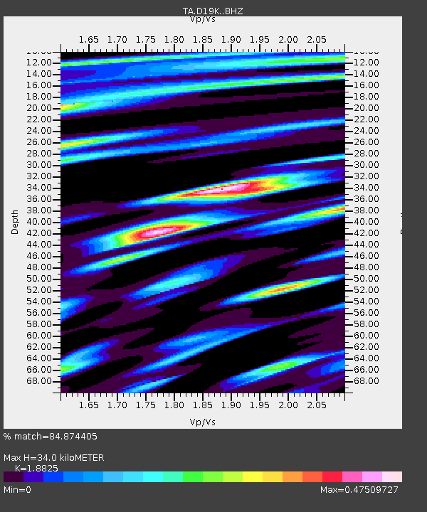
| Estimated Moho Depth: |
34.0 km |
| Estimated Crust Vp/Vs: |
1.88 |
| Assumed Crust Vp: |
6.221 km/s |
| Estimated Crust Vs: |
3.305 km/s |
| Estimated Crust Poisson's Ratio: |
0.30 |
|
| Radial Match: |
84.874405 % |
| Radial Bump: |
400 |
| Transverse Match: |
81.20769 % |
| Transverse Bump: |
400 |
| SOD ConfigId: |
13570011 |
| Insert Time: |
2019-05-01 20:18:25.550 +0000 |
| GWidth: |
2.5 |
| Max Bumps: |
400 |
| Tol: |
0.001 |
|

Signal To Noise
| Channel | StoN | STA | LTA |
| TA:D19K: :BHZ:20181116T03:38:51.824995Z | 7.3294063 | 1.6964086E-6 | 2.3145239E-7 |
| TA:D19K: :BHN:20181116T03:38:51.824995Z | 1.3603104 | 1.7673423E-7 | 1.2992199E-7 |
| TA:D19K: :BHE:20181116T03:38:51.824995Z | 1.2593116 | 2.3752922E-7 | 1.8861832E-7 |
| Arrivals |
| Ps | 4.9 SECOND |
| PpPs | 15 SECOND |
| PsPs/PpSs | 20 SECOND |


