You are here: Home > Network List > TA - USArray Transportable Network (new EarthScope stations) Stations List
> Station Q14A Sevier Lake (BLM), Delta, UT, USA > Earthquake Result Viewer
Q14A Sevier Lake (BLM), Delta, UT, USA - Earthquake Result Viewer
| Earthquake location: |
South Of Fiji Islands |
| Earthquake latitude/longitude: |
-26.0/-177.5 |
| Earthquake time(UTC): |
2007/12/09 (343) 07:28:20 GMT |
| Earthquake Depth: |
152 km |
| Earthquake Magnitude: |
7.0 MB, 7.8 MW, 7.7 MW |
| Earthquake Catalog/Contributor: |
WHDF/NEIC |
|
| Network: |
TA USArray Transportable Network (new EarthScope stations) |
| Station: |
Q14A Sevier Lake (BLM), Delta, UT, USA |
| Lat/Lon: |
38.99 N/113.28 W |
| Elevation: |
1464 m |
|
| Distance: |
88.2 deg |
| Az: |
44.606 deg |
| Baz: |
234.187 deg |
| Ray Param: |
0.042434253 |
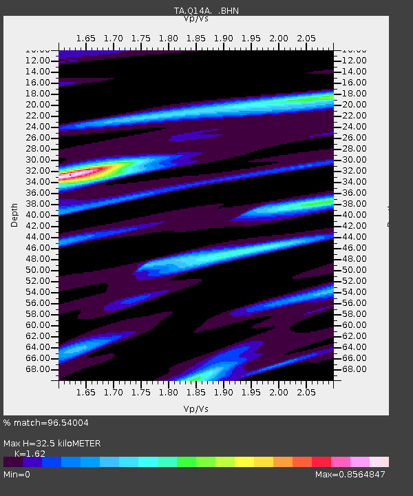
| Estimated Moho Depth: |
32.5 km |
| Estimated Crust Vp/Vs: |
1.62 |
| Assumed Crust Vp: |
6.276 km/s |
| Estimated Crust Vs: |
3.874 km/s |
| Estimated Crust Poisson's Ratio: |
0.19 |
|
| Radial Match: |
96.54004 % |
| Radial Bump: |
286 |
| Transverse Match: |
88.62929 % |
| Transverse Bump: |
371 |
| SOD ConfigId: |
2564 |
| Insert Time: |
2010-03-06 18:04:38.107 +0000 |
| GWidth: |
2.5 |
| Max Bumps: |
400 |
| Tol: |
0.001 |
|

Signal To Noise
| Channel | StoN | STA | LTA |
| TA:Q14A: :BHN:20071209T07:40:23.299004Z | 2.2512515 | 2.499383E-7 | 1.1102193E-7 |
| TA:Q14A: :BHE:20071209T07:40:23.299004Z | 1.694189 | 2.6393798E-7 | 1.5579018E-7 |
| TA:Q14A: :BHZ:20071209T07:40:23.299004Z | 5.634981 | 1.1685005E-6 | 2.0736547E-7 |
| Arrivals |
| Ps | 3.3 SECOND |
| PpPs | 13 SECOND |
| PsPs/PpSs | 17 SECOND |


