You are here: Home > Network List > TA - USArray Transportable Network (new EarthScope stations) Stations List
> Station G31M Satah River, YT, CAN > Earthquake Result Viewer
G31M Satah River, YT, CAN - Earthquake Result Viewer
| Earthquake location: |
Solomon Islands |
| Earthquake latitude/longitude: |
-10.5/163.1 |
| Earthquake time(UTC): |
2018/11/16 (320) 03:26:55 GMT |
| Earthquake Depth: |
11 km |
| Earthquake Magnitude: |
6.2 mww |
| Earthquake Catalog/Contributor: |
NEIC PDE/us |
|
| Network: |
TA USArray Transportable Network (new EarthScope stations) |
| Station: |
G31M Satah River, YT, CAN |
| Lat/Lon: |
66.92 N/134.27 W |
| Elevation: |
61 m |
|
| Distance: |
89.3 deg |
| Az: |
20.488 deg |
| Baz: |
240.826 deg |
| Ray Param: |
0.041923013 |
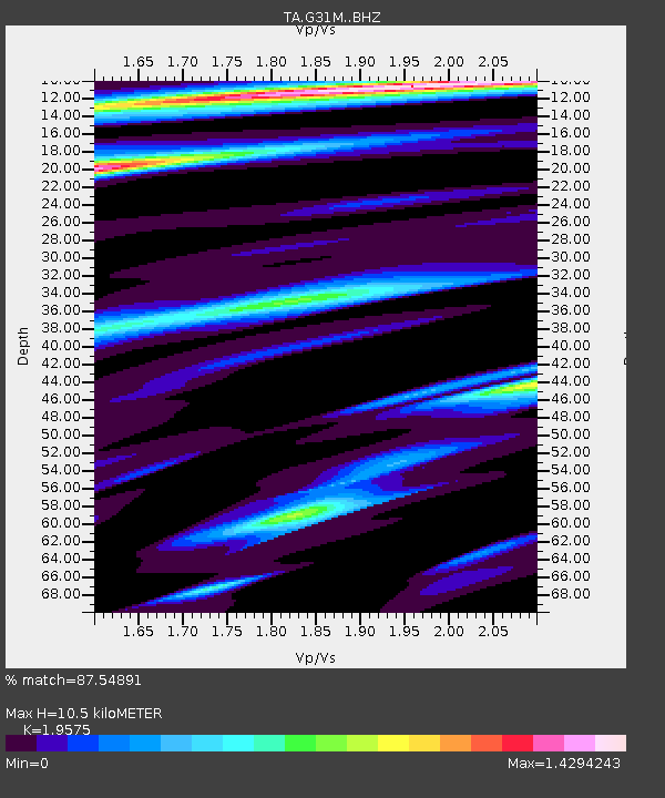
| Estimated Moho Depth: |
10.5 km |
| Estimated Crust Vp/Vs: |
1.96 |
| Assumed Crust Vp: |
6.171 km/s |
| Estimated Crust Vs: |
3.153 km/s |
| Estimated Crust Poisson's Ratio: |
0.32 |
|
| Radial Match: |
87.54891 % |
| Radial Bump: |
400 |
| Transverse Match: |
58.945045 % |
| Transverse Bump: |
400 |
| SOD ConfigId: |
13570011 |
| Insert Time: |
2019-05-01 20:19:01.822 +0000 |
| GWidth: |
2.5 |
| Max Bumps: |
400 |
| Tol: |
0.001 |
|
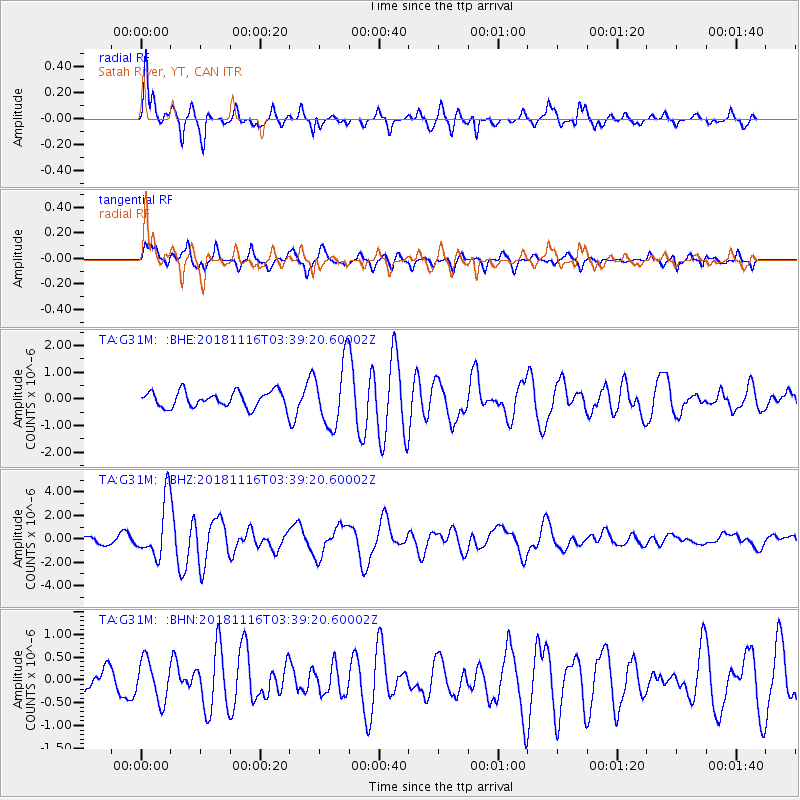
Signal To Noise
| Channel | StoN | STA | LTA |
| TA:G31M: :BHZ:20181116T03:39:20.60002Z | 8.628458 | 2.4895066E-6 | 2.8852276E-7 |
| TA:G31M: :BHN:20181116T03:39:20.60002Z | 1.5915519 | 4.458626E-7 | 2.8014333E-7 |
| TA:G31M: :BHE:20181116T03:39:20.60002Z | 3.7406487 | 1.0751711E-6 | 2.8742903E-7 |
| Arrivals |
| Ps | 1.7 SECOND |
| PpPs | 4.9 SECOND |
| PsPs/PpSs | 6.6 SECOND |


